|
While the Grand Canyon is Arizona's most famous destination, the state is also home to many other national forests, national parks and monuments. On this trip we visited several notable ones, namely,
Sunset Crater-Wupatki National Monument,
Tuzigoot National Monument,
Canyon de Chelly National Monument,
Petrified Forest National Park,
Casa Grande National Monument,
Organ Pipe Cactus National Monument, and
Saguaro National Park.
More than a quarter of Arizona's territory is Federal Trust Land which serves as the home of the Navajo Nation, the Hopi and other native american tribes. The section of Arizona Indian Country on Hwy 264 from Tuba City/Moenkopi to Ganado passes through sere and barren landscape with vast vistas from the the road. Plenty of panoramic views are availabe from atop tall mesas that the road climbs up and down. We also explored the area along Dine' Tah "Among the People" Scenic Road that passes through the Navajo Nation taking in ancient ruins, museums and other attractions along the way. |
 The photo album can be accessed
here.
The photo album can be accessed
here.
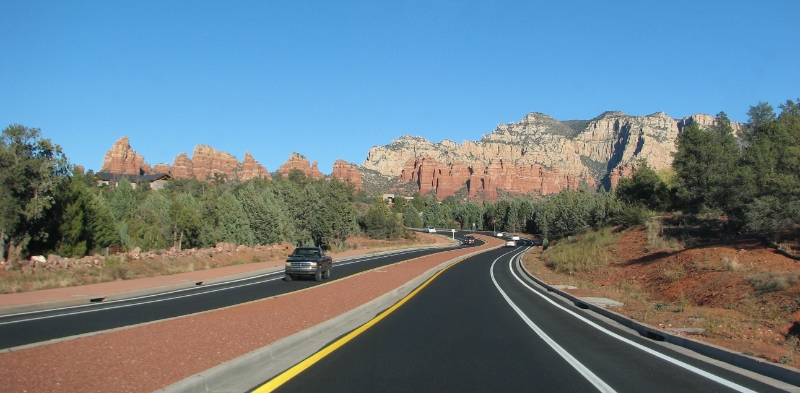
| Day 1 | Fly into Phoenix. Red Rock Country scenic drive from Prescott to Flagstaff through Sedona. |
| Day 2 |
Visit Sunset Crater-Wupatki National Monument. Drive Hwy 89 north to Tuba City.
Hwy 264 east through Arizona Indian Country.
North Hwy 191 north to Chinle. Canyon de Chelly South Rim drive. |
| Day 3 |
Canyon de Chelly North Rim drive,
Indian Road 12 through Dine'Tah to Lupton
Hwy 40 east to Petrified Forest National Park. Drive through Salt River Canyon to Globe. |
| Day 4 |
Roosevelt Dam and Apache Trail.
From Globe, Hwy 60 west and 79 south to Casa Grande National Monument at Coolidge Interstate 40 east to Gila Bend, Hwy 85 south to Organ Pipe National Monument via Ajo Hwy 86 west to Tuscon. |
| Day 5 | Arizona-Sonora Desert Museum and Saguaro National Park Drive to Phoenix |
Total Miles driven: 2000
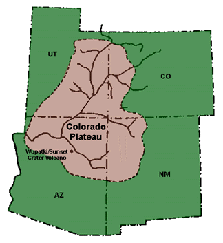
| While the state is noted for its desert landscape, less well known is the pine-covered high country of the Colorado Plateau in the north-central portion of the state. The Colorado Plateau is roughly centered on the Four Corners region and includes northwest Arizona. About 90% of the area is drained by the Colorado River and its main tributaries. In the southwest corner of the Colorado Plateau lies the Grand Canyon of the Colorado River. Much of the Plateau's landscape is related, both in appearance and geologic history, to the Grand Canyon. |
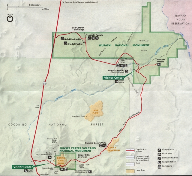
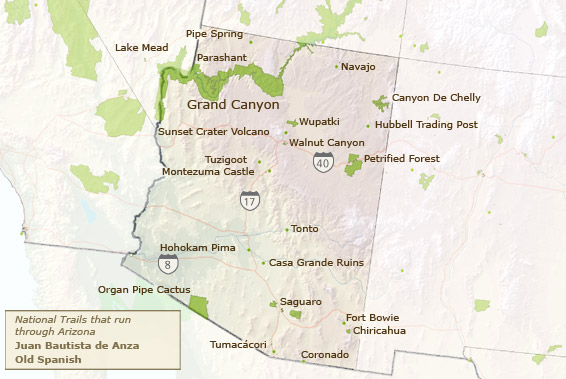
Sunset Crater Volcano National Moument / Wupatki National Monument map |
The Sunset Crater Volcano National Monument is located in the northern central part of Arizona, less than 15 miles north of Flagstaff, protecting over 3,000 acres of lava fields, cinder deposits and archaeological ruins. It is one of the youngest volcanoes of the Colorado Plateau. Following its eruption hundreds of years ago, the early settlers moved on to nearby Wupatki and Walnut Canyon. What remains are today fragments of the early villages protected today as archeoalogical sites. A one mile self-guided loop trail at the base of Sunset Crater Volcano, that takes visitors back in time to the early 11th and 12th centuries, before the volcano changed this impressive landscape. The same loop road that passes Sunset Crater Volcano National Monument, passes through Wupatki National Monument, one of several sites preserving pueblos of ancient peoples. The many settlement sites scattered throughout the monument were built by the Ancient Pueblo People, more specifically the Sinagua, Cohonina, and Kayenta Anasazi. Wupatki was first inhabited around 500 AD. A major population influx began soon after the eruption of Sunset Crater in the 11th century (between 10401100), which blanketed the area with volcanic ash. The pueblos all have a distinctive deep red color and were made from thin, flat blocks of the local Moenkopi sandstone. |
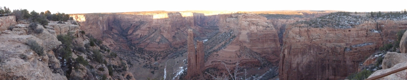
 Canyon de Chelly National Monument

 Petrified Forest National Park
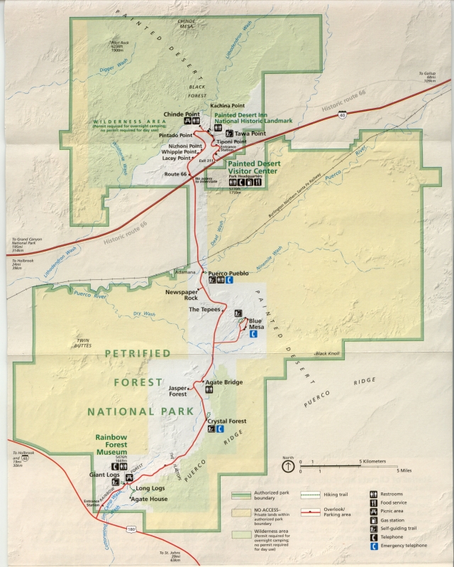
Petrified Forest National Park - park map |
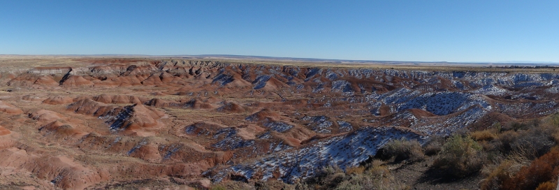
Petrified Forest National Park straddles the border between Apache County and Navajo County in northeastern Arizona. Named for its large deposits of petrified wood, the park covers about 146 square miles, encompassing semi-desert shrub steppe as well as highly eroded and colorful badlands. The northern part of the park extends into the Painted Desert, which was declared a National Monument in 1906 and a national park in 1962. The park contain America's largest deposits of petrified wood, a rich and colorful desert, many fossils of dinosaurs and other creatures, and more than 500 archaeological sites including amazing petroglyphs left by ancient cultures. A 28-mile park road offers overlooks with long-distance vistas of the Painted Desert and Petrified Forest. The "Painted Desert" is located in the northern section of the park. Portions of this land were declared the nation's first wilderness are in the National Park System in 1970. The colors in the desert result from the minerals in the soil; the characteristic red color is due to iron oxides. |
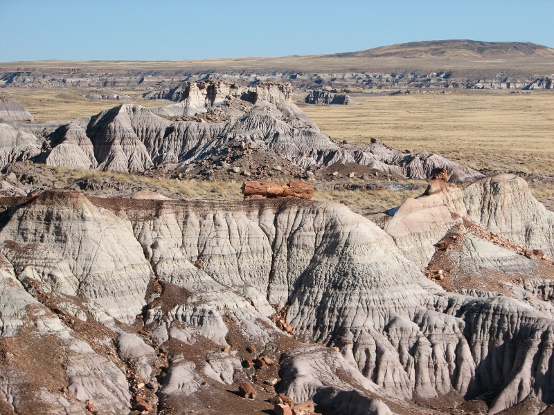
Petrified log balanced on an eroding ridge at Blue Mesa |
One of the most striking areas in the park is the fabulous Blue Mesa in the east central section. It is where some of the most impressive fossils were found and more are being discovered each year as erosion exposes new evidence. Fossils found here show the Forest was once a tropical region, filled with towering trees and long-extinct creatures. Several different species of fossilized plants, animals and reptiles have been discovered by paleontologists.
When trees were toppled by volcanic eruptions, they were swept away by flowing water and deposited in marshes and covered with mud and volcanic ash. Buried under layers of sediment, the logs remained buried for millions and millions of years undergoing an extremely slow process of petrification which essentially turned the logs to colorful stone. Blue Mesa offers a fascinating window into this process. The area became covered with an ocean covering the logs with even more sediment. About 60 million years ago the ocean disappeared and was replaced with flowing rivers that gradually eroded over 2,600 feet of sediment depth slowly exposing the petrified wood that litters the landscape at the Petrified Forest National Park. Logs are still embedded in stone - as the rocks weather away, the petrified logs are exposed bit by bit. |
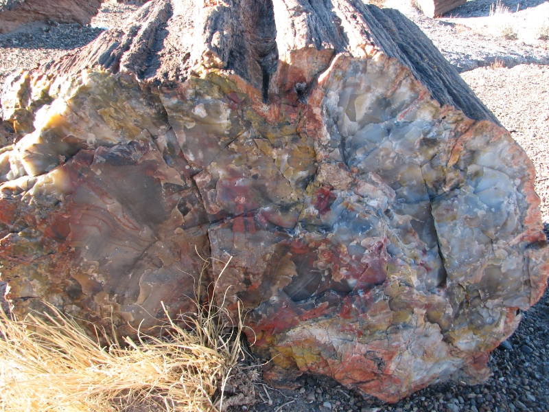
Petrified log at Crystal Forest |
Over millions of years, mineralized water replaced the cellulose fiber in a process that preserved some of the structure of tree rings and grain. Most of the resulting rock is silica in a non-crystalline form, colored by other minerals. Voids in the logs are often filled with crystals of quartz and amethyst. |
Organ Pipe Cactus National Monument
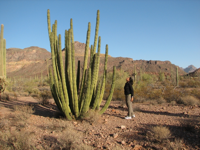
Organ pipe Cactus |
The main road through the park, Hwy 85, heads straight south towards the international border with Mexico.
The northern part of the monument is in fact dominated by Saguaro which outnumbers Organ Pipe cacti in the park and we were a little confused about this. As it turns out the Organ Pipe Cactus is a gultton for heat and light and grows only on the warmer southern slopes where it can absorb the most sunlight.
Like its fellow cacti and other desert inhabitants, the organ pipe is attuned to rhythms of the sun and infrequent rains. When it blooms in the heat of May, June and July, it waits until the sun sets to open its lavender-white flowers. The main backcountry scenic route in Organ Pipe Cactus National Monument is the Ajo Mountain Drive, a mostly unpaved loop that heads towards the foothills of the Ajo Range, the high, rocky ridge which forms the eastern boundary of the preserve. |
Saguaro National Park
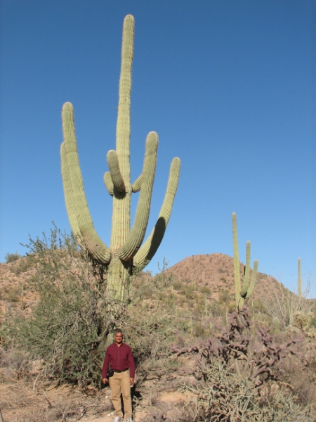
Saguaro on the Scenic Bajada Loop Drive |
The saguaro begins its life as a shiny black seed no bigger than a pinhead. What it lacks in size, it more than makes up for in numbers. One saguaro produces tens of thousands of seeds in a year. Saguaro seedlings that grow under sheltering plants such as palo verde and mesquie are shaded from the desert's intense sunlight, blanketed from winter cold, hidden from rodents, birds and other animals that eat them.
A saguaro's growth is extremely slow. Growth occurs in spurts, with most of it taking place in the summer rainy season each year. After 15 years, the saguaro may be barely a foot tall. At about 30 years saguaro can begin to flower and produce fruits. By 50 years, the saguaro may be as tall as 7 feet. After about 75 years, it may sprout its first branches or "arms." The branches begin as prickly balls, then extend out and upward. By 100 years the saguaro may have reached 25 feet. Saguaros that live 150 years or more attain the grandest size, towering as much as 50 feet and weighing 8 tons, sometimes more, dwarfing every other living thing in the desert. These are the largest cacti in the United States. Their huge bulk is supported by a strong but flexible cylinder-shaped framework of long woody ribs. The saguaro collects water with a network of roots that lies about 3 inches below the surface and stretches as far out from the main stem as the saguaro is tall. In a single rainfall, these shallow roots, along with special small root hairs that grow in response to moisture, may soak up as much as 200 gallons of water, enough to last the saguaro a year. Saguaros may die of old age, but they also die of other causes. Animals eat the seeds and seedlings, lightning and winds kill large saguaro, and severe droughts weaken and kill all ages. The saguaro is vulnerable during every stage of its life. Seen here in addition to the Saguaro is the Ocotillo and the prickly-pear cactus. |
Below is the link to the YouTube playlist. These are HD videos and can be viewed at 720p if you have a high speed internet connection.
Click here for the KMZ file for the trip. This can be opened in Google Earth.
Alternatively, you can view the waypoints and trip tracks in Google Maps below.