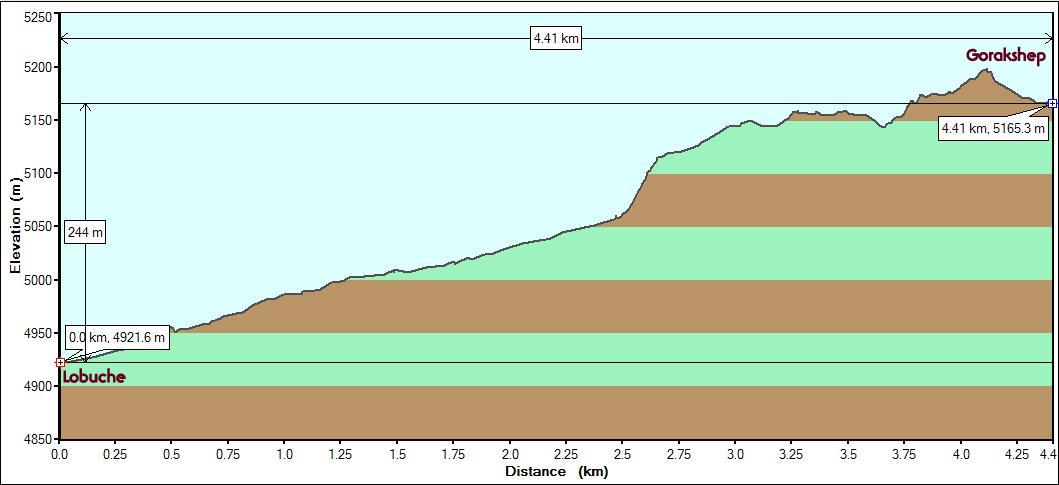
Starting
point : Lobuche (Altitude: 4921m/16150 ft. StartTime:
7:30 am)
Endpoint : Gorakshep (Altitude:
5165m/16950 ft. End Time: 9:40 am)
Distance : 4.4 km/2.75 miles
Net Elevation
Gain/Loss : 245m/800 ft.
Everest Base Camp 2008 - Day 8
|
Starting
point : Lobuche (Altitude: 4921m/16150 ft. StartTime:
7:30 am)
|
So far, we'd had some good nights and bad nights in terms of sleep and rest. A good night is when you think you've been awake all the time but when you check your watch you are surprised to see that it is 2 hours past what you thought it will be. That could only mean that you fell asleep despite yourself. And when it shows anytime past 4:30 am, you are delighted as it means that you have less than 2 hours before daylight. This is totally unlike what we would feel at home where the thought of daybreak fills (at least one of) us with dread.
The night at Kalo Pathar Lodge at Lobuche will rank high on the list of the worst nights ever. Venkatesh was up every minute and tried sleeping in every imaginable position. Is the bed sloping on one side? Ok, lets try sleeping the other way around. No, that does not work. Lets try sitting up. But there is really no place to lean back on. Try leaning on the daypack. Lets take one more trip to the toilet even though you can wait. Trusting oneself to fall asleep while breathing the sparsely oxygenated air is difficult at this altitude (4900m/16150 ft.). You think you are going to fall asleep, but you wake up in a panic and realize that your regular breathing pattern is not feeding enough oxygen into your system. The anxiety that this brings on inhibits further sleep. Michael Palin talks about his difficulties in sleeping at high altitudes in his Himalaya TV series. He was, of course, on the other side of Everest, in Tibet.
We noticed that some of the occupants of the other wooden boxes had kept the door open. Given the cold, the only reason for this could have been to combat claustrophobia. We heard the occasional massive howling winds blowing outside. We were not sure if we could even walk in that weather if it persisted past the morning. Since the Asian style toilet was not really an enclosed area but right next to a storage area (wood, mostly) the winds penetrated through and brought up the dust. This brought on a coughing fit that was echoed across all the rooms. A coughing crescendo in one room will trigger an avalanche of similar crescendos in the other rooms (like dogs howling at night).
The arrival of daybreak on this day was welcomed with great relief and some anxiety over the amount of rest we got. We heard the phrase "not a wink" from others too, so it was not an exclusive experience. On the plus side, the wind had died down and it was a bright, clear morning with no sign of any approaching clouds.
To avoid a similar experience at Gorakshep (which had about 5 lodges only), our guide offered to proceed there early in the morning leaving us to have breakfast and walk with the porter. He claimed that he could cover the 4+ km. in an hour. This would increase our chances of our finding room there for the next night. Moreover, several trekkers avoid sleeping at Gorakshep (5290m/17350 ft.) and prefer to get to their destinations as a day trek from Lobuche. We were not in favor of such a plan as we wanted to cover both destinations (Everest Base Camp and Kala Patthar) and that would be extremely difficult to complete in a single day with the extra distance to Lobuche. We were surprised that sleeping in Gorakshep is going to be significantly different from sleeping in Lobuche as the altitude difference was less than 300m. But at these high altitudes, even the slight differences could turn out to be significant.
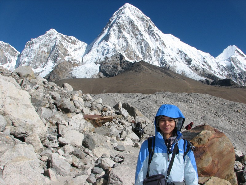
Our guide got going before 7 am. We were not far behind and hit the trail at 7:30 am. As expected, it was freezing outside and we were dressed in all the layers we had (5 top layers and 3 layers for the legs), woollen hat with the protective shell covering of the windproof jacket, gloves with the mitts bought at Namche and balaclavas. The sun was still behind Nuptse (which had a blanket of clouds draped over it on one side) as we walked on the thankfully gently sloped terrain. We walked on with Pumori front left and Nuptse to our right.
 Nuptse and the
boulders at the terminus of the Khumbu Glacier
Nuptse and the
boulders at the terminus of the Khumbu Glacier
The picture below captures the morning scenery quite well : From l-to-r: Pumori, Lingtren, Khumbutse and Changtse (partly hidden).
 Pumori (left), porter and
Venkatesh (fully wrapped up)
Pumori (left), porter and
Venkatesh (fully wrapped up)
After an hour's walk, we came across another memorial. This one was at the bottom of a steep slope which was much smaller compared to the one we had climbed yesterday. It was still an opportunity for a brief rest before we ascended. We had crossed the 5000m mark and were moving at a considerably slower pace.
 Even this modest ascent encourages trekkers to take a break
at this altitude
Even this modest ascent encourages trekkers to take a break
at this altitude
As we passed this slope and moved ahead, the Khumbu Glacier's rugged contours were revealed as the icy mass beneath the rocks were exposed in spectacular shapes.
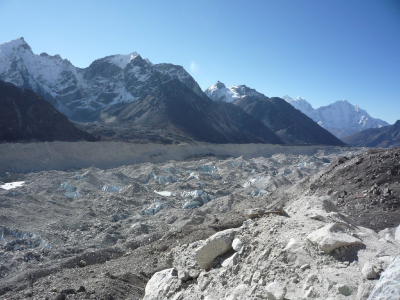 Khumbu
Glacier (Thamserku in the distance)
Khumbu
Glacier (Thamserku in the distance)
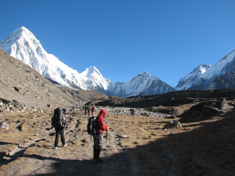
We soon got our first view of Kala Patthar with the magnificent Pumori (7,161m / 23,494ft) looming large behind it. Kala Patthar is not really a "major" peak, but just a hilly mound at the lower slopes of Pumori. But it has earned its own distinctive name and reputation due to its accessibility to trekkers on a short, straightforward trail (can be seen in the below picture) and the spectacular views of Mount Everest that can be enjoyed from its "peak". The mountain to the left of Pumori is Xi Lingehain (7101m, entirely in Tibet) and the snowy flat-headed mountain on the right is Lingtren (6749m, on the Nepal-Tibet border like most mountains on this range).
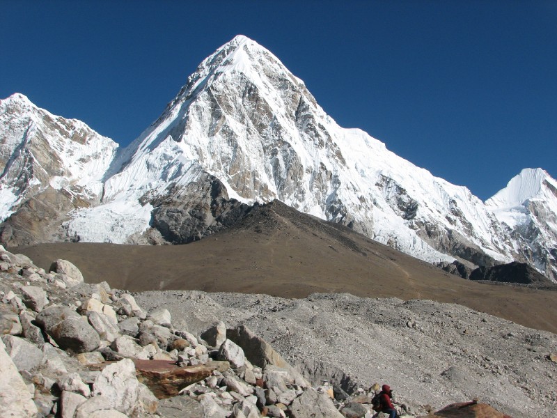 Kala Patthar and Pumori.
Pumori is flanked by Xi Lingehain and Lingtren
Kala Patthar and Pumori.
Pumori is flanked by Xi Lingehain and Lingtren
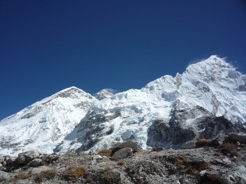
 V by the Khumbu Glacier
(Lingtren, Khumbutse, Changtse, Icefall behind)
V by the Khumbu Glacier
(Lingtren, Khumbutse, Changtse, Icefall behind)
 M (Kala Patthar, Pumori
and Xi Lingehain at left)
M (Kala Patthar, Pumori
and Xi Lingehain at left)
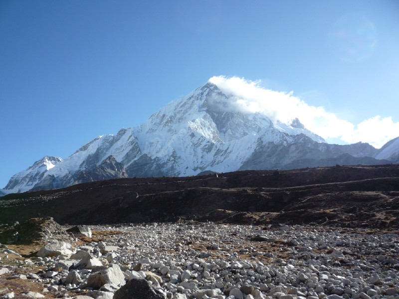
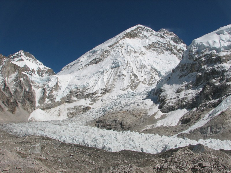
The trail started to go through a series of quick ascents and descents as if to mimic the glacial terrain to the right. Once we got to the top of one of these hills, we caught sight of Gorakshep below. The wavy Khumbu Glacier culminated in the distinctive look of the Khumbu Icefall ahead of us, to the right (see picture below). Also in the picture are the mountains Lingtren, Khumbutse and Changtse (behind the Lho La pass which is directly above the icefall).
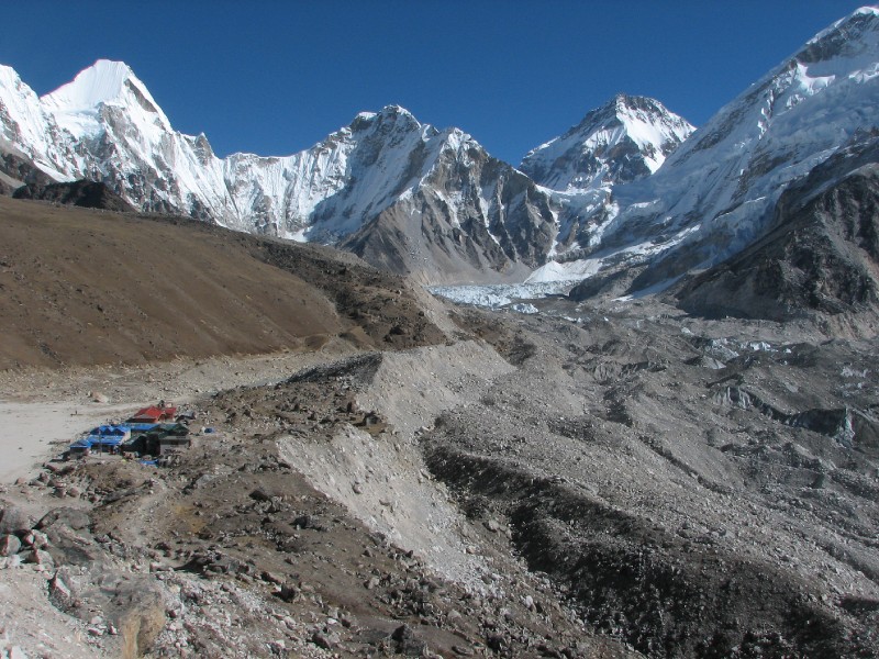 Gorakshep, Khumbu Glacier
and Khumbu Icefall
Gorakshep, Khumbu Glacier
and Khumbu Icefall
We quickly walked down and checked in to the Buddha Lodge and broke for lunch. This lodge was several notches above what we had got into at Lobuche. This was a newer construction with stone walls, well insulated from the cold and even had western style toilets.
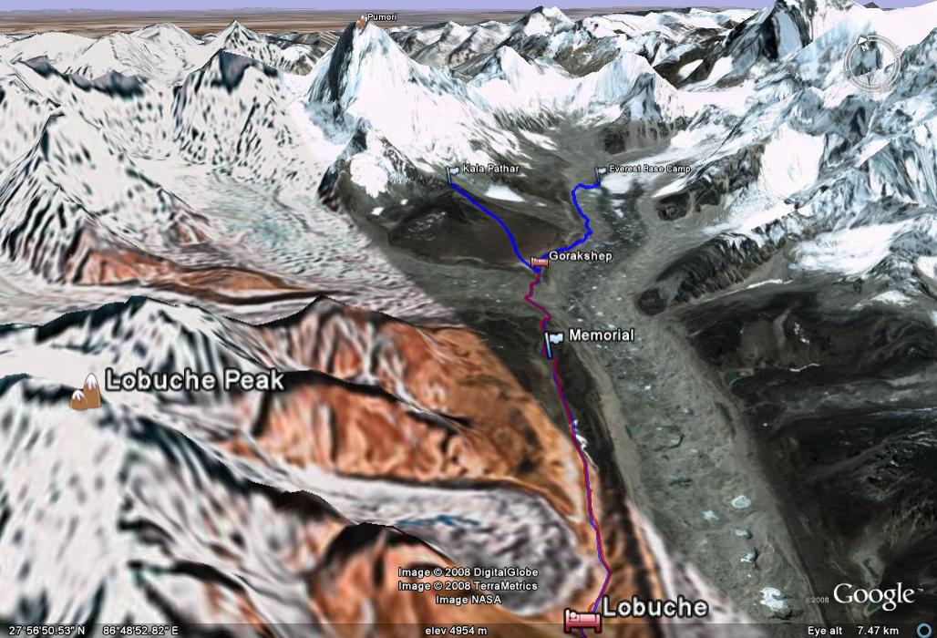
Google Earth view of the path from Lobuche to Gorakshep. Khumbu Glacier is to the right of the path. Kala Patthar and Everest Base Camp are ahead.
Plan for the afternoon: Given the clear, sunny day we considered the option of climbing Kala Patthar right after lunch. This would be taking advantage of the clear views while we had them. Who knows, we may get a cloud covered day tomorrow. We could still trek to the Everest Base Camp on a cloudy day as that trip is more about history and the proximity to the Khumbu Icefall and less about views. There would be really no point in climbing Kala Patthar (it is not a major mountain peak) unless it is a clear day with views of Mount Everest. On the flip side, this day was going to be the longest day of the entire trip (with an afternoon session instead of rest) and it made sense to pick the less strenuous of the two options. And that was clearly the Everest Base Camp trek with its less challenging elevation difference. So we opted to hike to Everest Base Camp after lunch. We will climb Kala Patthar early tomorrow morning and hopefully it will be a clear day like today.
We did not waste any time and after an excellent lunch (Dal, Bhat and Curry... imagine at 5300m, right near the base of a remote mountain range), we hit the trail at 11 am.
First, we walked past the vast sandy bank and then we had to skirt past the half-frozen lake by walking on boulders on its shore. We could see the familiar sideways profile of Nuptse (that is commonly seen in photos of Everest and surroundings) with its gracefully shaped peak.
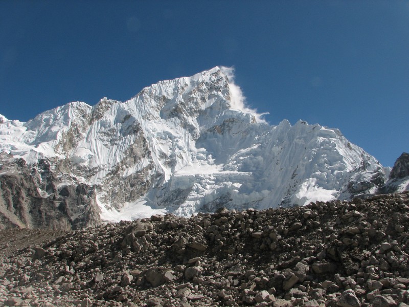 Nuptse
After negotiating a few bends with some climbing, we were on a ridge with the Khumbu Glacier down below to our right and a sheer drop to our left as well. There was the occasional falling of rocks on the side of the mountain to our left.
Walking on the ridge
towards Everest Base Camp
We knew that one could not see Mount Everest from the base camp but we were not aware that we could see it from this ridge. It made a surprising appearance through a gap in mountains to our right (Nuptse and an unnamed mountain which turned out to be attached Everest at its base). Initially only a slight edge could be seen with more of it becoming visible as we went along the ridge. After a while it started disappearing on the other side and eventually went out of sight. Here is the view with Everest from a midpoint where we could see the most of it during this hour.
Zooming in for a better look...This is as much of the mountain that we could fill in our view finder.
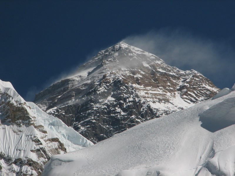 Mount Everest's southwest
face
Mount Everest's southwest
face
The disappearing act: In the picture at left below, Everest can still be seen hiding behind its own foothill. In the picture on the right, it has vanished.
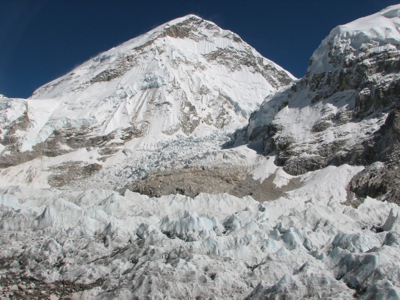
As can be seen in the above pictures, we were getting really close to the Khumbu Icefall (once we lost Everest, we started paying attention to the icefall). We could see the gap through which climbers will have to traverse the icefall as the first major step in their summit attempt.
Once we got past the ridge, the trail descended to the right side, then veered sharply and passed over the Khumbu Glacier. We tested the exposed ice and found that our poles could not even make a scratch on the hard surface.
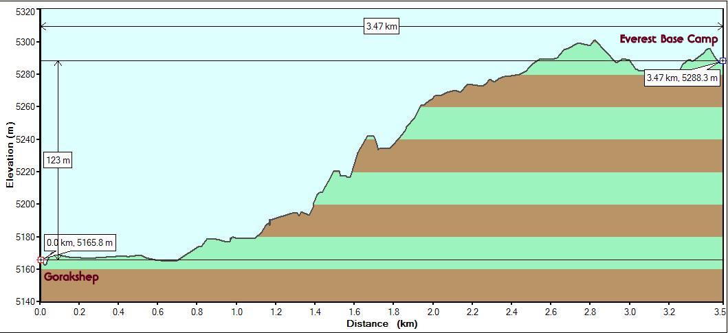
A few yards later we were at the stop where the original Everest Base Camp was. This is close to where Sir Ed camped with his team during their historic summit attempt. The base camp itself keeps shifting every year and the more recent sites were further ahead. We were not motivated to walk the extra distance over the rough terrain especially as this was not climbing season and there won't be any camps there. So we decided that this was it. Mission Accomplished as far as reaching Everest Base Camp was concerned. Our GPS showed that we had reached an altutide of 5288m (17350 ft.). We had walked close to 65 km (40 miles). It was 1:15 pm on the afternoon of Day 8. We had walked for 2 hours from Gorakshep.
Videos taken at the terminus of our Everest Base Camp trek
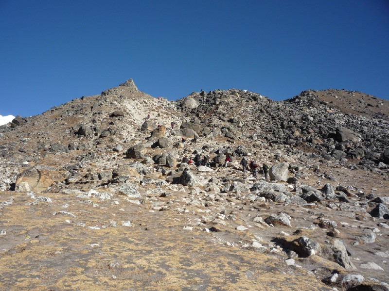
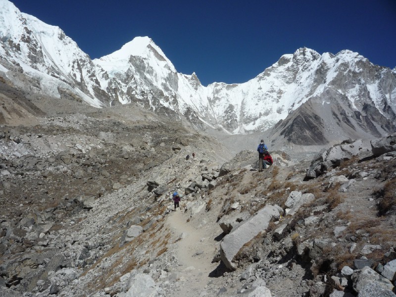
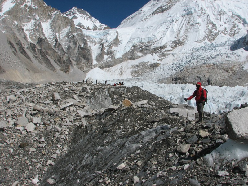
The below picture shows trekkers close to the Everest
Base Camp (our turnaround point). One can see the granite hard ice peeking from
below the rocky surface. Also seen in the picture is the Lho La Pass (6000m) and the mountain behind is
Changtse at 7,543 metres (24,747 ft)
elevation. It is entirely in Tibet across the border. The ice saddle that is in
front of it is the Lho La Pass. This is the pass which George Mallory climbed from the Tibetan side in
1922 and pronounced the Khumbu Icefall
"unclimbable". He said this with relief as Nepal was out of bounds to foreigners
before WWII.
 Trekkers at Everest Base
Camp
Trekkers at Everest Base
Camp
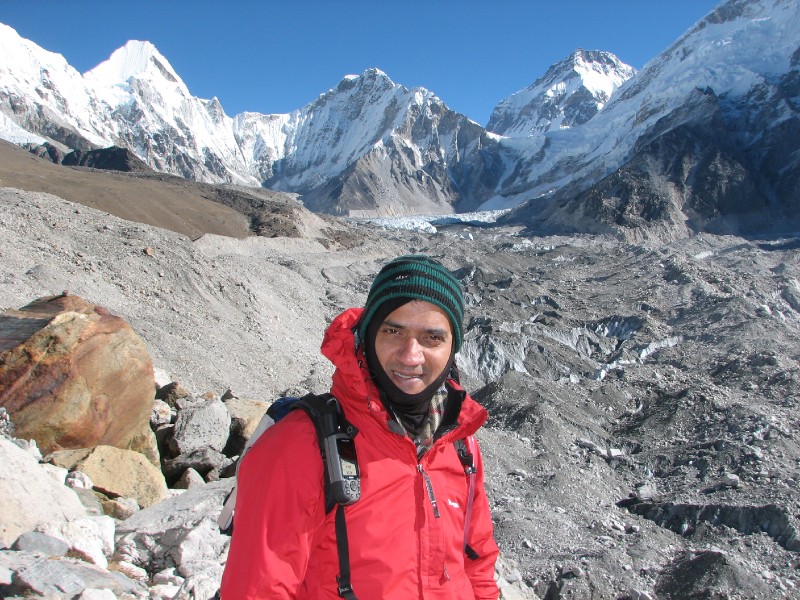
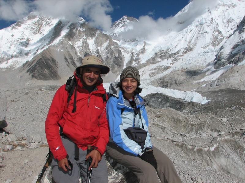 Day 8 and 40 miles later
at elevation 5300m/17350 ft.
Day 8 and 40 miles later
at elevation 5300m/17350 ft.
We retraced our route back to Gorakshep and were back by 3 pm. We did feel tired after the long day especially after a sleepless night. But it felt good to have one objective completed.
Here is a trip report from the spot. As this report is being typed, the complaining about the Lobuche lodge seems excessive, but this was how we felt then.
Just returned to Gorakshep from Everest Base Camp and shot in the heat of the moment.
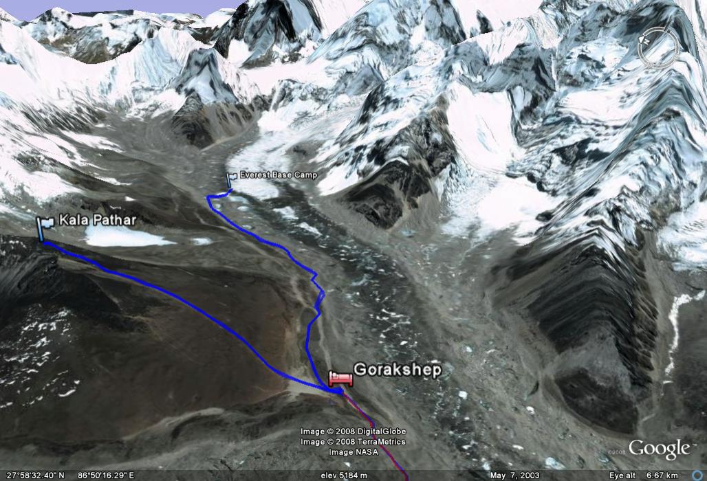
Google Earth view of the 2 destinations - Everest Base Camp and Kala Patthar.
| <--Prev |