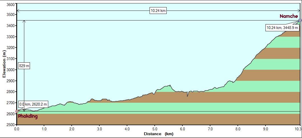
Starting point
: Phakding (Altitude:2620m/8600ft. Start Time: 8 am)
End point :
Namche Bazaar (Altitude: 3440m/11320ft. End Time: 12:45 pm)
Distance:
10.25 km./6.4 miles
Net Elevation Gain/Loss : 830m/2700 ft.
Everest Base Camp 2008 - Day 2
|
Starting point
: Phakding (Altitude:2620m/8600ft. Start Time: 8 am)
|
When we started in the morning, we knew that this day was going to be harder than the previous day with its net elevation gain of 800+ metres. However, we did not know that the bulk of it will be tightly squeezed into the last 3 km. It began with 3 crossings of the Dudh Kosi on long bridges. In between was a stop at Monju at the gate to Sagarmatha National Parkfor permit verification. The center also exhibits a 3-D model of the area. The entrance gate had colorful Tibetan Buddhist figures painted on the inside and a row of prayer wheels.
The gate led to a set of steps going down to the level of the river and after crossing to the other side on a bridge, we stopped at the town of Jorsalle for a break. Our guide told us that there will be no refreshments available after this till we reach Namche Bazaar . This would be the first time since we started the trek the previous day that we'll enter a pure wilderness area. It would also be a steep climb, but will offer spectacular views.
Eager to get going and wary of attempting a strenuous climb post lunch, we opted for snack bars and decided to have lunch late at Namche. We immediately crossed back to the other side of the river over another long bridge with the Dudh Kosi frothing away milkily to our left. We spotted a very high suspension bridge crossing the river again up ahead. Our guide told us that this was the Hillary bridge .
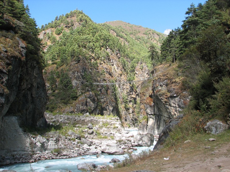 Hillary bridge over Dudh
Kosi. The steep climb to Namche will start after.
Hillary bridge over Dudh
Kosi. The steep climb to Namche will start after.
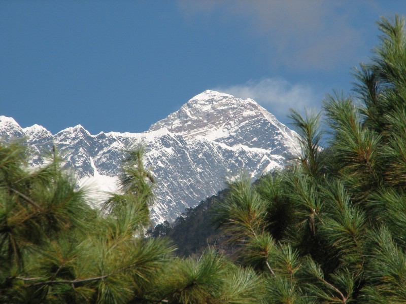
Steep steps led us to the bridge and after crossing, we had to climb down another set of steep steps. But before long we were climbing steadily switching back and forth over the river valley. Kusum Kanguru peeked a little from behind the clouds. After a half hour of the steep climb, our attention was drawn to someone taking a picture of something through the trees. We could not see what it was, but on stepping right onto a single spot, we could see what the excitement was all about. Our first view of Everest peak from terra firma. High winds were blowing off snow from its south face. We could discern the shape of the peak and the obscuring wall in front of it that connected Lhotse to Nuptse , neither of which were visible from here. Given the number of mountains that were between where we were and Mount Everest , this is an extraordinary stroke of chance.
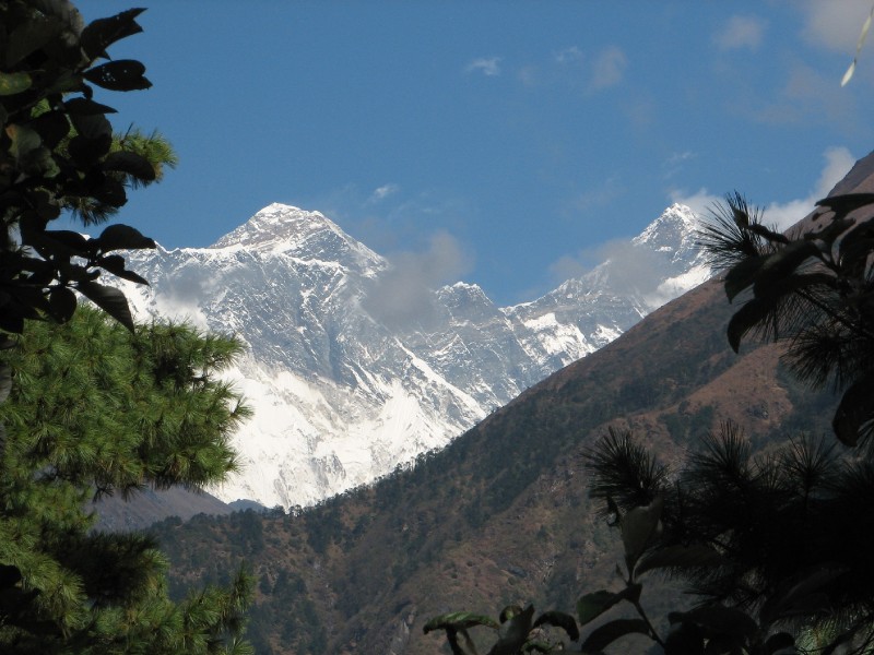
Another 25 minutes of steep climbing brought us to a clearing by the side of the trail with several people taking photographs. The view from this point was much wider. This time, the view included Lhotse as well, some clouds obscuring the view somewhat.
Satisfied with this happy development without being frustrated by a total cloud cover, we attacked the steep trail with renewed spirits and after another hard hour of climbing through a wooded trail, we started seeing buildings ahead. After stopping briefly on the outskirts (!) of Namche , we carried on. We had to stop at another checkpost for permit verification. Our guide told us that we still have to climb a lot through the town before reaching our lodge. Fair warning, otherwise the endless climbing of steps through the "streets" of Namche Bazaar would have been frustrating after the hard work of the past hour and a half.
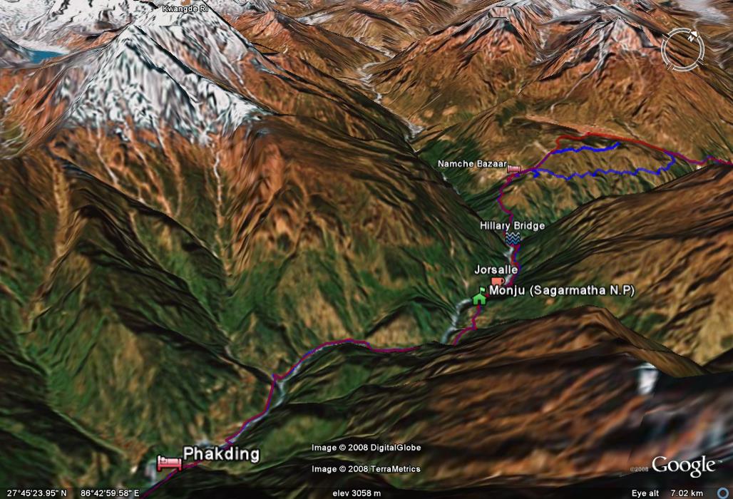
Day 2 path in Google Earth : The profile of Kwangde Ri changes significantly after reaching Namche. The steep ascent after Hillary bridge can be seen. Everest could be seen at 2 spots on this stretch.
Our room at Namche Inn had sweeping views of the horseshoe shaped town. We could see the Tibetan market right below and the imposing series of peaks above. This turned out to be the other side of Kwangde Ri (6178m) whose southern profile we had seen the previous day froms Lukla .
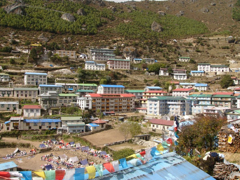 Namche Bazaar with Tibetan market in the center
below
Namche Bazaar with Tibetan market in the center
below
The town of Namche Bazaar (Altitude 3400m) is growing rapidly and we could hear the incessant construction noise over the call of a crow.
We ordered lunch at the dining hall and it took a full hour to materialize. We watched an Everest video on the DVD Player in the dining hall. The hall had sweeping views of Kwangde Ri and the town from all sides. We were nauseous from the effort (not from altitude) but thankfully it did not last. However, we were quite cold in our rooms after lunch. Our bag hadn't arrived and we missed our sleeping bags. It turned out that our porter had assumed that we would eat lunch at Jorsalle and had waited there for long, not realizing that we had skipped and moved on. He did show up eventually and we were happy to get into our sleeping bags.
After an hour's rest, we felt better. One feels colder (and sometimes nauseous) when one is tired. This pattern would repeat through the next few days. The more strenuous the hike, the colder we would feel in the afternoon. We did as most folk who stay in these lodges do. Adjourn to the dining room where a fire is usually started in the late afternoon. That is when the fog rolls in outside and the chills brings everyone out of the rooms and into the dining area. The yak dung is fed into the burner with an exhaust tube flowing upwards through the roof. It takes a half hour for the heat to pick up. Till then the early birds hover around the metal box in touching distance. The heat eventually kicks in and everyone starts slowly inching away in an expanding circle. This is just as well as more people have joined in by then and the extra space created by the expanding circle makes room for additional chairs. This ritual was repeated every day for the rest of our trip on the mountains at all the lodges.
| <--Prev |