Everest Base
Camp 2008 - Day 3
Day 3: Thursday,
October 23, 2008
|
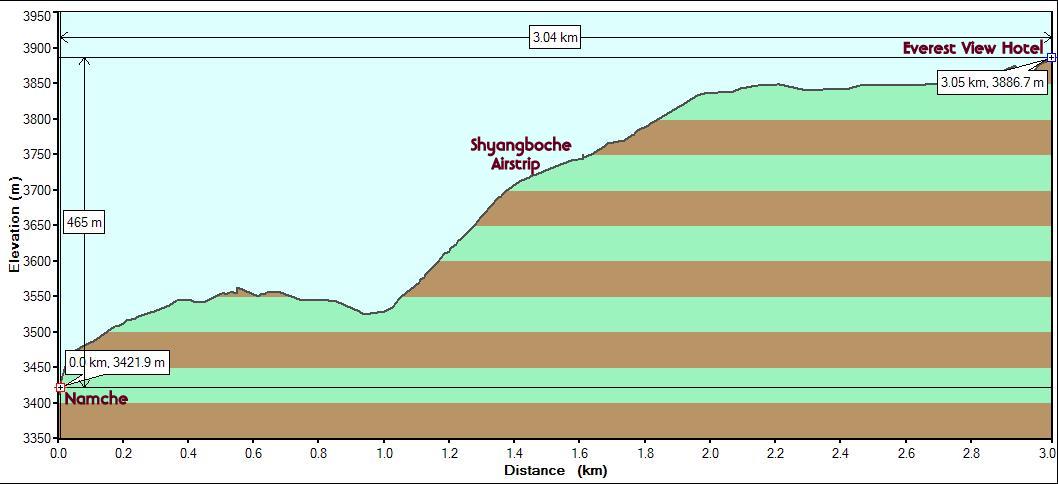
Starting
point : Namche Bazaar (Altitude: 3420m/11190ft. StartTime: 7:45
am)
Interim point:
Everest View Hotel (Altitude: 3880m/12750 ft. End Time: 10:15 am)
Endpoint: Returned to Namche Bazaar (End
Time: 11:30 am)
Distance: 3 km/1.9 mi (one way).
5km/3.1 mi (round trip)
Net Elevation Gain/Loss: 465m/1560 ft. (one
way). Zero (round trip).
|
The plan for the day was to do an acclimatization trek
to a higher altitude and then return back to Namche to sleep one more night at
the current altitude. We had the option of a full day trek to
Thame but decided to go for the half-day trek to the Everest View Hotel (3880m/12730ft.) after visiting
the museum at the Namche Visitor Center first thing in the morning.
We got an early start (7:45 am) after an early breakfast in the freezing cold.
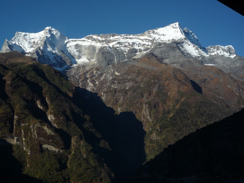
Unlike the previous afternoon, Kwangde Ri
was glowing with the rays of the morning sun with no cloud cover at all.
 Kwangde Ri (taken from
Namche Inn dining room)
Kwangde Ri (taken from
Namche Inn dining room)
We needed extra thick layers, woollen hat and gloves as
we walked in the shade. As soon as the sun came up from behind Kusum Kanguru, things started to get better. It
was a stiff climb (100m) to the Namche Visitor Center and we took it easy
due to the cold limbs and altitude. 15 minutes was all it took. Before going
inside the visitor center to view the museum exhibits, we were diverted by the
panorama that became visible in front of us. The 100m climb was all it took for
us to rise above the Namche bowl and see the skyline. What we saw was
stunning.
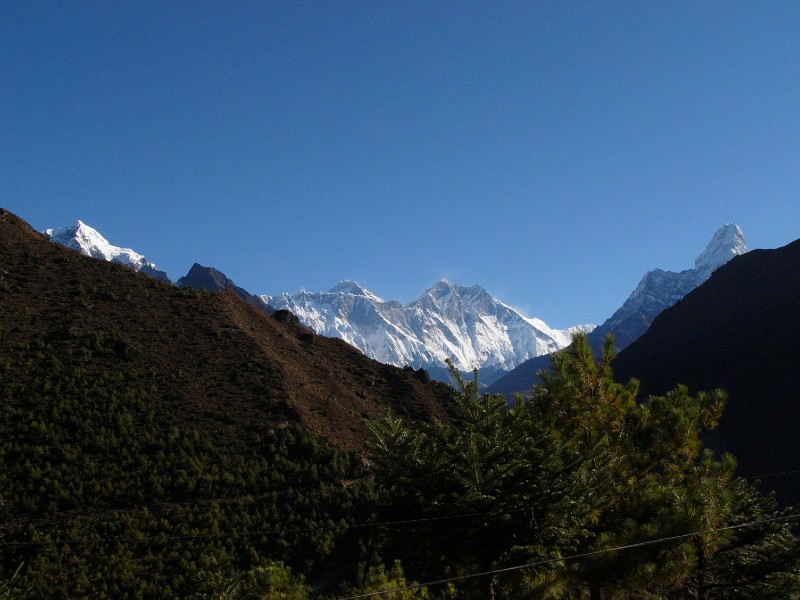 Our first stunning panoramic view of the trip
Rising up over the horizon are from l-to-r : Tawoche (6542m/21460ft.), Everest (just the peak visible over the obscuring
wall), Lhotse (8516m/27940ft), Lhotse Shar (the sharp peak that is to the
immediate right of Lhotse and actually connected to it). The other mountains of
that high range (called Mahalangur Himal
which extends from Cho Oyu to Makalu and includes Nos. 1, 4, 5 and 6) are
obscured by the uniquely shaped Ama Dablam
(6812m/22350ft.). We were looking forward to our first sighting of Ama Dablam having heard so much about this
mountain. It was reputed to be one of the most beautiful on the planet (among
others like the brilliant looking Alpamayo
in Peru) and we identified it immediately from its distinctive shape. This
shape is used in the logo of Invesco corporation. In the above picture, Ama Dablam
is the snow covered peak at right. Not seen in this pic, Kusum
Kanguru and Thamserku loomed
large over the east, but had the sun behind them.
The museum had interesting displays and photographs
about the mountaineering history of the region. The stories are well known, but
it was interesting to see pictures of the region taken in the 60s and 70s and
contrast them with how they are today.
We came down the hill from the museum and were soon
faced with the task of the day. A steep slope on the side of a mountain that
resembled a ski slope with its curving path.
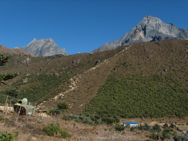 Steep slope from Namche Bazaar to the Shyangboche
airstrip
Steep slope from Namche Bazaar to the Shyangboche
airstrip
At the top of this path (gaining about 200m on this
stretch) is the Shyangboche airstrip.
Unlike the Lukla runway, this is not a
paved runway and only helicopters and small private planes can land here. The
airstrip was built to serve the nearby Everest View
Hotel (primarily targeted at wealthy Japanese tourists). Apparently,
there were plans to extend the runway and upgrade it to land larger aircraft but
they haven't materialized. These plans also upset the commercial interests in
Lukla who felt that they would lose business if a competing runway is built at
Shayangboche which is much closer to the Khumbu Valley destinations and will
eliminate the hard trek from Lukla.
The climb took us 45 minutes in the heat (yes, it got
very hot as the sun was up and it was hard work). The airstrip (Altitude: 3729m)
did not inspire confidence.
 Shyangboche
airstrip
Shyangboche
airstrip
The trail, less steep now, still climbed steadily upto
the Shyangboche Panorama Hotel . Once
again we were distracted by the panorama that reappeared, but with fewer barriers
than in the morning. The view was made more dramatic by the presence of a yak. As
can be seen below, a lot more of Tawoche can be seen at left and almost all of
Ama Dablam can be seen at right, due to
our having reached a much higher altitude compared to the morning views at the
Visitor Center. The Everest-Lhotse group
looked almost the same as they were much further away.
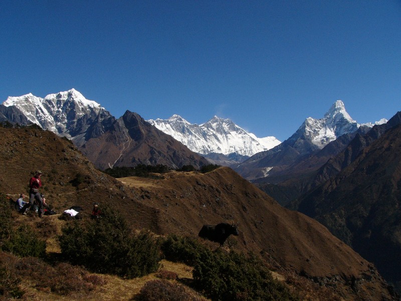
l-to-r: Tawoche, Everest, Lhotse,
Lhotse Shar, Ama Dablam
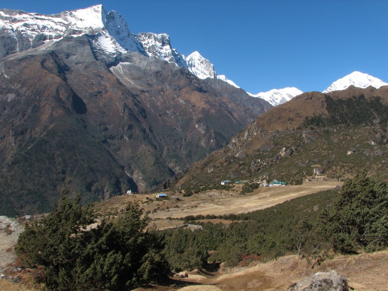
We could see the trail to Tyangboche (which would be our route for
tomorrow) deep down below as well as a chorten on the trail. We could even see the Tyangboche Monastery with our camera in full
telephoto mode. It seemed a bit too close compared to the description in our
guidebook that specified the distance from Namche to Tyangboche as being 20km. We knew that it involved
a steep descent to the river and then a steep ascent to the monastery, but 20km.
seemed excessive. Most books on the area prefer to focus on timings and
elevation changes rather than distances. However, they have to make allowances
for a variety of trekkers and so always quote a low and high value. We feel that
this leaves out a crucial objective measure out of the equation and were
thirsting for this information. We discussed this with our guide who made
contemptuous remarks about book writers and said that the correct distance
should be something like 16km! This was hardly the reduction that we had in
mind. We will let our GPS decide tomorrow.
The trail skirted around a corner on the mountain
side and soon, we came across a steep drop on a short undulating path
leading us to the Everest View Hotel. The
pricey hotel charges $150 or so for a room with extra charges for the use of
oxygen cylinders. The deck was full of day hikers who had hiked from Namche for acclimatization or a cup of tea. We
found a table free and spent a half hour admiring the view (not much different
from the one seen above, except that you could see the town of Phortse as well) and chatting with other
trekkers over Lemon Tea (which we were getting addicted to). We even met some
Europeans who had lived in our neighbouring city of San Carlos, California!
It was nearing mid-day and the sun had risen quite a bit
allowing us to pay close attention to Thamserku on the east with its brilliant crisply
folded walls of ice.
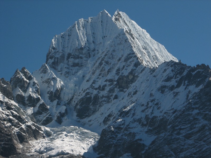 Thamserku
We returned back to Namche by noon for lunch and a brief rest. We got
a very different perspective on Namche from the trail as we were directly above
it.
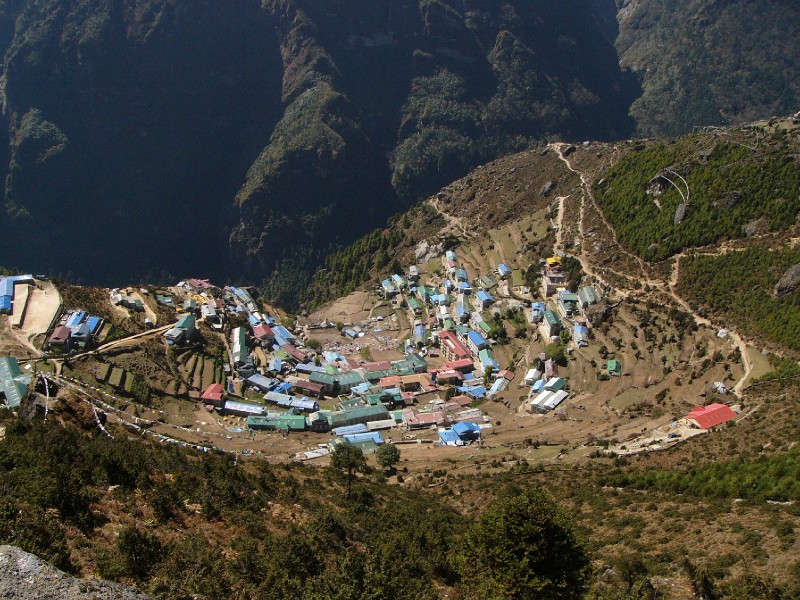 Namche Bazaar from above
We explored the marketplace in the afternoon and bought
glove mitts for the Kala Patthar climb on Day 9 and some souvenirs. We also
visited the Tibetan market briefly before climbing back to our lodge for dinner.
Having done the right thing by staying an extra night at this altitude, we began
our daily dose of Diamox (125mg) before going to sleep.
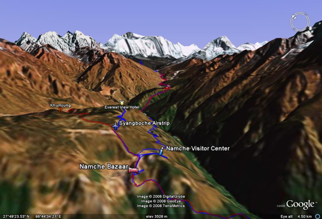
Day 3 path in Google Earth: This one has been tilted almost
horizontal to mimic the pictures above, but also shows the path traversed to the
Everest View Hotel. Note the parallel blue path extending down towards the
valley (that was the path for Day 4)