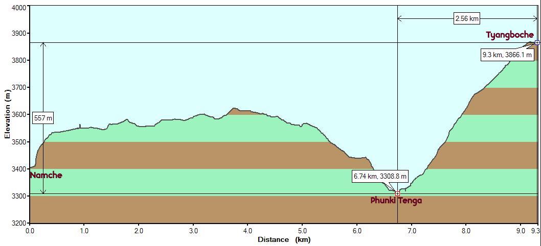
Starting
point : Namche Bazaar (Altitude: 3420m/11190ft. StartTime: 7:50
am) Endpoint: Tyangboche (Altitude:
3865m/12680ft. End Time: 1:10 pm) Distance: 9.3 km (5.8
miles) ------> Thank you, GPS!
The truth is finally out! Net Elevation Gain/Loss: 445m/1490 ft.
Yet another early start (7:30 am, when it was really
cold) presumably to increase our chances of finding room in a good lodge at
Tyangboche. It would get progressively
difficult as we moved uphill. It made for a really uncomfortable 30 minutes in
the beginning, mostly due to the extra layers of clothing that inhibits movement
and the cold limbs that take time warm up. The route almost maintained the same
latitude/longitude coordinates of the previous day's trail to Everest View Hotel, only several hundred feet
below.
The trail was a genuine mountain trail with no sign of
any towns along the way. The animal traffic had also reduced significantly. The
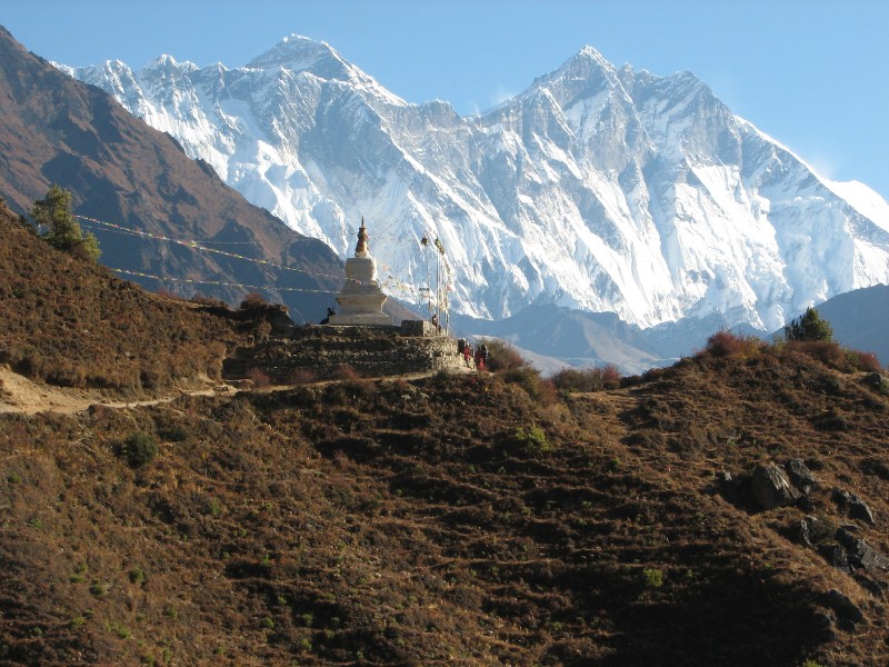
first landmark we encountered was the chorten
that we had seen from above, the previous day. It made an impressive sight
as foreground for the backdrop of Everest-Lhotse. After going past it and walking to
the next turn on the mountain, we turned back and viewed Kwangde Ri. The two chorten views are seen below.
We could also see all the way back to the park entrance
(as a tiny spot which our cameras could not capture well) and the Dudh Kosi
river at the bottom of the deep green divide.
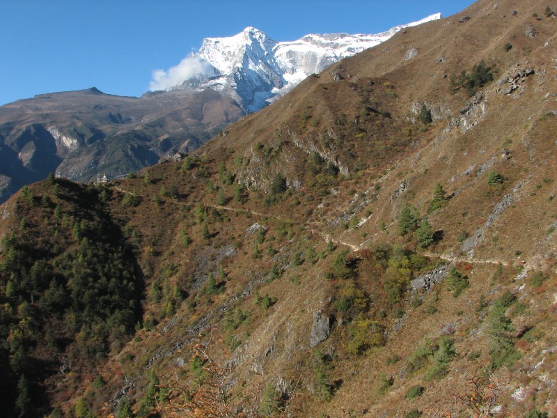
The first point of interest on the way was the 4 way
crossroads at Sanasa. The northbound trail
forks here with one going up (the sign says 7 hours) to Gokyo and the other staying level towards
Tyangboche. Another arm climbs up back towards where we came from to Khumjung (20 minutes to). We would take the Khumjung route on our return.
A mountain shaped like a snow saddle appeared just
behind Thamserku. This turned out to be
Kang Tega (6685m/21900 ft.) which
eventually turned out to be a series of unnamed peaks stretching
east-west. These (along with Thamserku) could be seen throughout the
rest of our upward trip all the way to Kala
Patthar.
Kang Tega (snow saddle)
and Thamserku
We heard a pair of Nepali boys singing and only saw them
later.
Nepali boys heard and later, seen.
After climbing gently to 3600m we could see the trail
switching back and forth beyond the divide just ahead of us. This was the steep
ascent to Tyangboche that we'll encounter
after first descending to Phunki Tenga
(3300m/10860 ft.). Several details can be seen in the photograph below. The town
of Phortse can be seen center-left (below
Tawoche peak). The Dudh Kosi river can be seen in the shadow below.
It splits into two at Phunki Tenga (seen
bottom-center exposed to the sun) where the Dudh
Kosi veers left towards Gokyo and
the Imja Khola veers right in the general
direction of Mount Everest. And finally,
we can see the steep switchbacks (center) exposed in the sunlight, that has
been cut on the mountain directly above Phunki
Tenga which eventually becomes a long stretch from left to right. The
Tyangboche Monastery is also in the
picture as a tiny speck on the top of this mountain (directly below Lhotse Shar). These switchbacks will present a
long and relentless climb later this afternoon.
Compare with Google Earth
image below
Soon, the much awaited descent to the river started. It
got thickly wooded and the going was tough on the very rocky, steep trail. We
could see the effort on the faces of trekkers climbing towards us. We knew that
we would face the same music after crossing Phunki
Tenga. We got to Phunki Tenga at
about 10 am (after 2 hours of walking). We crossed the bridge bidding goodbye to
Dudh Kosi and hello to Imja Khola.
After breaking for tea (no, we are not playing Test
Cricket here) at a Phunki Tenga restaurant, we began our climb. This was much
harder than the climb to Namche (Day 2) or
the climb to Everest View Hotel (Day 3)
because of the fact that we had no breaks for views (as in Day 2) and the fact
that we could not see the destination (which we could on Day 3). It was like
climbing an endless spiral staircase with no visibility above. But we could see
Phunki Tenga down below occasionally and
the deeper it got, the better we felt. We did encounter some stiff animal
traffic and some sections had steep drops down the mountain and we tried not to
get on the cliff edges while avoiding the animals. These hefty animals were
carrying very heavy loads and were strongly motivated by bellowing cattleherds
and were in no position to take evasive action to avoid hitting trekkers. It was
upto the trekker to stay out of harms way.
On this stretch, the ascent was 557m/1827ft. over a very
short 2.5 km/1.6 miles. The altitude was > 10000 ft. and that meant heavier
breathing and heavily palpitating hearts. One had to carefully pace oneself to
avoid overexertion and also to avoid altitude sickness. The fact that we had
slept the extra night at Namche after
hiking high the previous day helped us here. The good books advise this strongly
and this was honored by our tour company in our schedule. The book even suggests
to those trekkers who make a common mistake "If you
left Namche with a headache, then consider staying at the lodge in Phunki Tenga.
It is at a lower elevation and will help you recover. If you disregard this and
climb up to Tyangboche, you are just inviting trouble".
Day 4 path in Google Earth: This time it was the lower path
down to the valley. The lowest point is Phunki Tenga where the Dudh Kosi veers
left. Our path veered right and climbed steeply to Tyangboche.
The welcome sight of the monastery gate appeared at
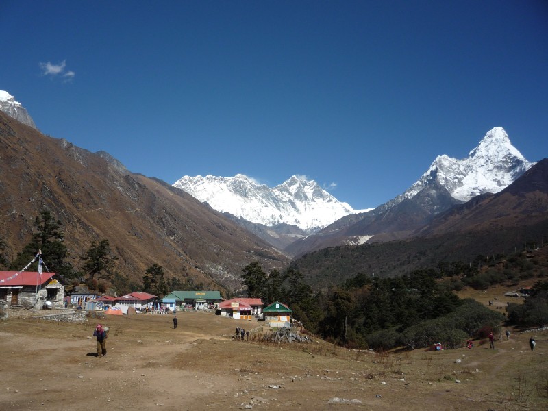
around 12:15 pm. We walked through the gate to this magnificent sight. Everest/Lhotse/Lhotse
Shar and Ama Dablam (at Tyangboche)
Sure, we'd been seeing this on and off for the past 2
days, but we did not come all the way here to say
"Oh, no, not Everest again!". Directly in front was a bakery that served fancy cakes made on
site. Next to it was an internet cafe (proudly boasting "at 3880m"). Up ahead in the
distance is the village of Pangboche which we would see tomorrow. To our left
(not in the pic) was the monastery and to our right (not in pic) were
a couple of lodges, one of which had a room for us. This was the Taschi Delek
("Good Luck to you" in Tibetan) lodge.
The Tyangboche
Monastery is the spiritual center of the Khumbu Valley. It's gompha (not in pic) was
visible to Tenzing Norgay and he pointed
it out to Sir Ed Hillary on their
summit day on Mount Everest in 1953. Since
then, it has burnt down and has been rebuilt.
Some videos of the area...
Yak herd in front of Tyangboche Monastery
Room with a view at Tashi Delek Lodge at
Tyangboche
After lunch at the lodge (Thentuk and Thukpa), we walked
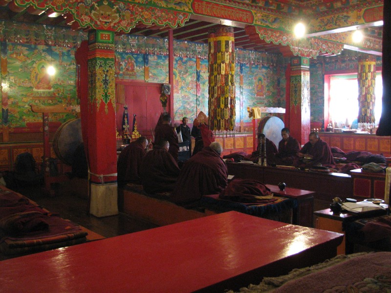
to the bakery for some coffee cream cake. Then, we walked across to the
monastery and sat down in the prayer hall and solemnly listened to the
monks' chanting, which was trance-like and punctuated with loud blasts of an
overly long brass instrument whose one end rested on the ground and whose mouth
piece was played by a monk sitting at a high stage. The chanting was
multi-voiced with a lead voice that was at a high register with a lilt at
the end of every phrase, while the backup voices lent support at a lower
register. Towards the end of a stanza the heavy brass pair sounded off
ceremoniously.
We returned for the 4' o clock ceremony as well. A young
monk with some limited English, berated the trekkers who were trying to gain
entrance to the prayer hall before the "Incarnation Lama" had even arrived. The
other monks seemed to be in a much higher spiritual plane and were not bothered
by the presence of the trekkers. The novice monk added his own rule ("No
photos") to the one already posted on the notice "No videos, No tripods, No
flash, No kissing etc.". This later ceremony was interrupted by the occasional
serving of hot drinks to the monks, who sipped quietly and solemnly in between
prayers. The Incarnation Lama held the prayer sheet close to his eyes. Another
monk sat right at front with a helmet that had a metallic sheen and had 3 spades
sprouting from it as well as a grotesque skull figure grinning with large
reddish teeth. Most of the trekkers seemed respectfully appreciative of this
serene experience. Some wore expressions of respectful incomprehension.
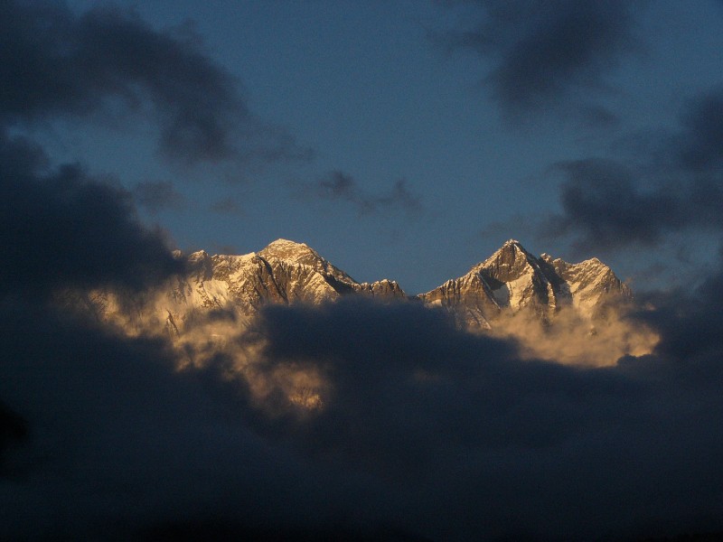
Given that the sun rises behind Everest in Nepal, the only opportunity to get a
photo of Everest with that golden orange glow is at sunset. Despite the
overall clear weather we had enjoyed thus far, the afternoons typically see
thick clouds roll in and obscure the high peaks. It would take a determined
photographer who would hike to a vantage point at sunset time. Fortunately, this
latter problem did not exist at Tyangboche
as the view was directly in front of our lodge and even from our rooms. However,
the cloud problem still proved to be a significant one. We were teased till it
was almost time before the curtains were shut. All we got was this at 5:15 pm.
And then it was gone.
Our best sunset photo of
Everest from this trip
Finally, a word on the
distance covered on the trail from Namche to Tyangboche. Our GPS put the figure
at 9.3km/5.8 miles. That is nowhere near the figure quoted in one of the books
(19 km/12 miles). Our guide's estimate of 16 km. was also completely
incorrect.
After dinner, our guide sprang a surprise on us by
declaring that we would proceed to Pheriche tomorrow and then Lobuche the day after.
Our schedule had us going to Dingboche and
staying there 2 nights before proceeding to Lobuche on Day 7. We were supposed to stay at
Pheriche on our return. We were concerned
with both alterations. First, we were not about to break the prescribed
acclimatization schedule of 2 nights at 4300m. Next, we had read enough about
potential day-treks for the acclimatization day and they were closer to Dingboche than Pheriche. Granted, there was only a small ridge
separating the two and it was barely a half hour walk with an elevation
difference of 100m between the two. When challenged with this, he simply said
"Up to you" and said something inexplicable about us having already crossed
5000m during our 2005 trip to Kilimanjaro and that we did not need to
acclimatize at 4300m. The absurdity (acclimatization is not something you
accumulate over your lifetime, you have to start from scratch for every trip;
once you return to sea level you would lose the acclimatization) of this statement stunned us. We decided to
think this over at night and decide in the morning.
 Kang Tega (snow saddle)
and Thamserku
Kang Tega (snow saddle)
and Thamserku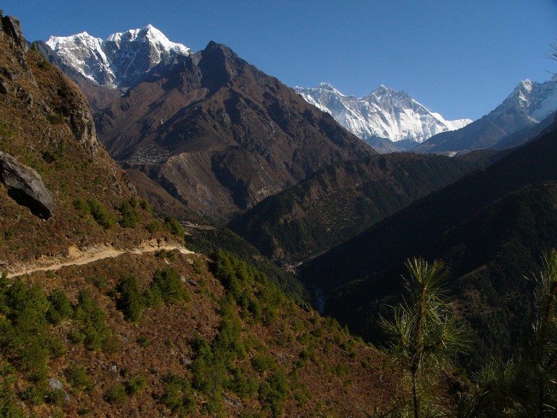 Compare with Google Earth
image below
Compare with Google Earth
image below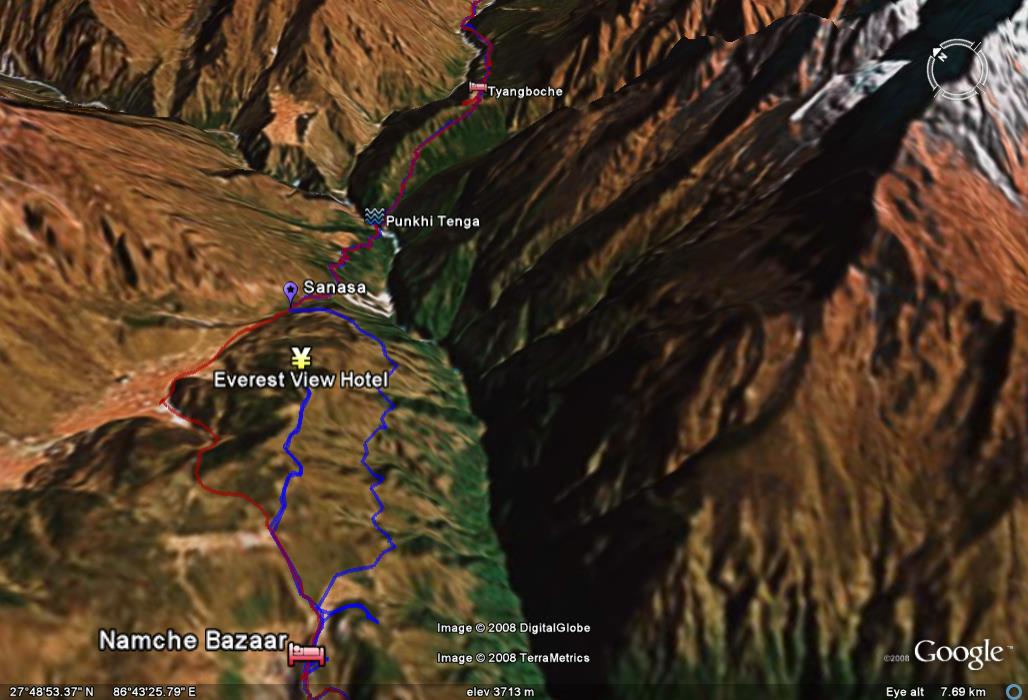
 Everest/Lhotse/Lhotse
Shar and Ama Dablam (at Tyangboche)
Everest/Lhotse/Lhotse
Shar and Ama Dablam (at Tyangboche)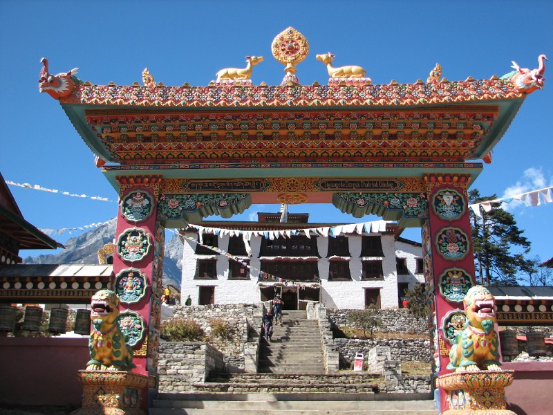
 Our best sunset photo of
Everest from this trip
Our best sunset photo of
Everest from this trip