Starting
point : Tyangboche (Altitude: 3865m/12680ft. StartTime: 8:15 am)
Endpoint :
Dingboche (Altitude: 4330m/14200ft. End Time: 1:15 pm)
Distance
: 10 km./6.25 miles
Net Elevation Gain/Loss: 465m/1520 ft.
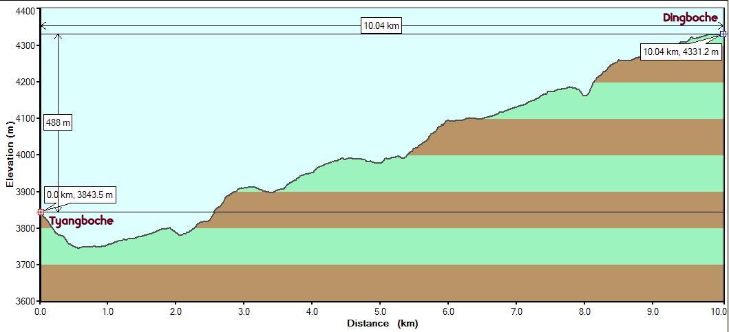
Everest Base Camp 2008 - Day 5
|
Starting
point : Tyangboche (Altitude: 3865m/12680ft. StartTime: 8:15 am)
|
Even the best of nights saw us awake well before dawn. The bad ones had us waking up every hour and staying up trying to get back to sleep. This got worse as we got higher in altitude. Once we accepted this and counted every hour of sleep as a big positive, we started feeling better. Lack of sleep is quite common which we kept hearing from other trekkers. One just takes what one gets and moves on. At Tyangboche, the early morning opportunity to get a sunrise photo (even though it would be behind Everest) presented itself. The cloud cover had vanished overnight.
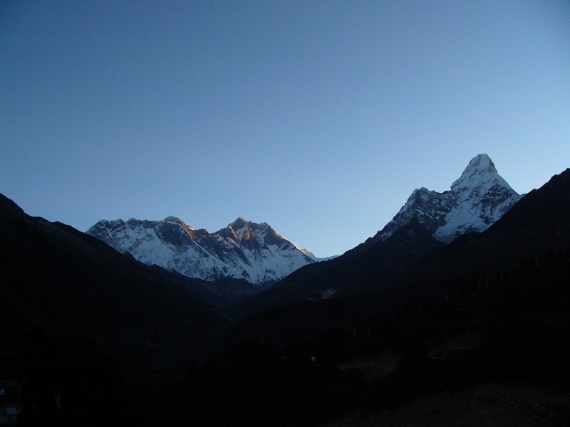 The best sunrise photo of
Everest we took on this trip
The best sunrise photo of
Everest we took on this trip
This morning featured a later departure (8:15 am) than the previous two days. Having got up early (we rarely stayed in our sleeping bags past 6 am) we could have left earlier, but the cold outside discouraged early starts. We firmly told the guide that we wished to stick to the planned schedule and go to Dingboche and stay 2 nights there. No debates.
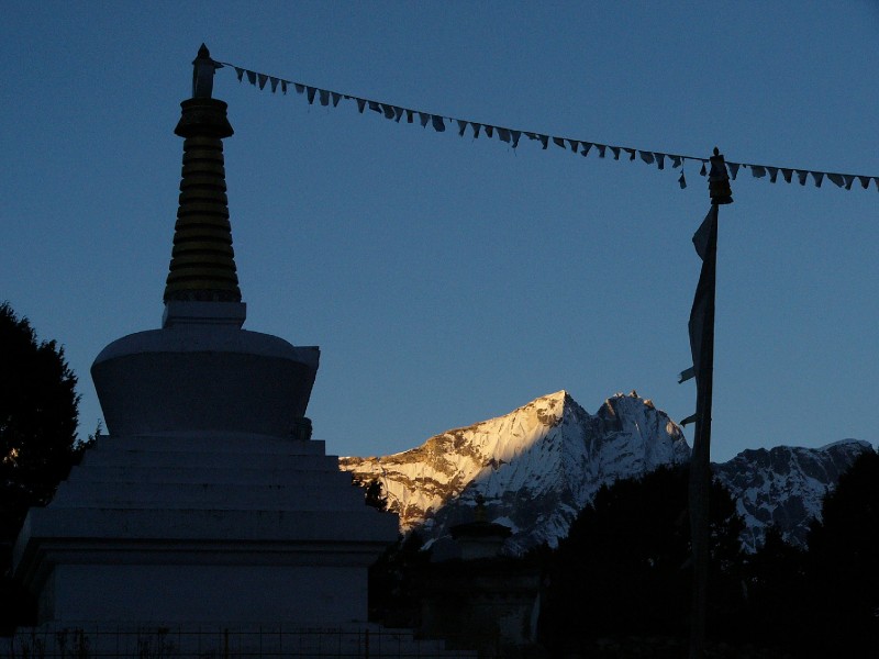 The Tyangboche Gompha and Kwangde
Ri
The Tyangboche Gompha and Kwangde
Ri
This day would get us up another 450m but over a comfortable 10km. It would get us past the 4000m mark before ending at Dingboche at 4330m. We expected to have lunch after we got there.
Immediately past the wide meadow, the trail descended steeply through a wooded section. The trail had a wide path that retained a regular width with neatly arranged rocks. It was easier to walk outside the path on the soft earth. It was still chilly and uncomfortable. The trail levelled off and we were clear of the trees as we neared Deboche which had a few upscale lodges catering to richer clients. Despite having slept after taking Diamox the previous night, we felt the familiar tingle in our hands and the buzz in our faces. We kept the extra layers on for a while till we got warmed up from the walk and the appearance of the sun. We noticed that the view upfront was changing and that the tip of Everest was now barely visible over the obscuring wall. It will soon completely disappear from view and will only reappear on Day 8 after we reached Gorakshep.
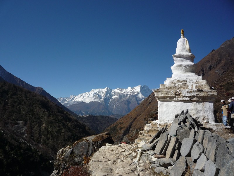
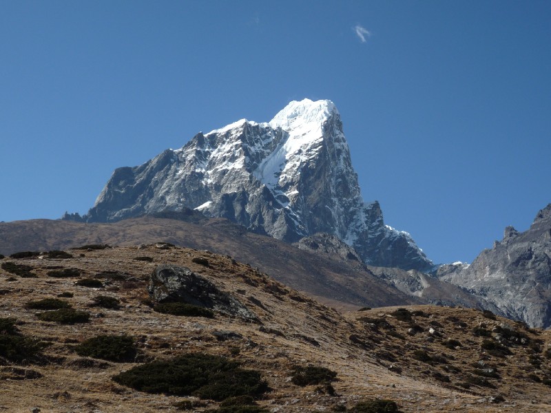
After the dip at Deboche, the trail started climbing again and soon we were level with the monastery. We could see it behind us with Kwangde Ri magnificently hanging right over it.
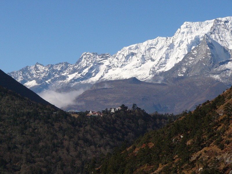 The Tyangboche Monastery
(the white gompha can be seen clearly)
The Tyangboche Monastery
(the white gompha can be seen clearly)
Twenty minutes later we passed a gompha on the way and could not resist another photo of the monastery with its stunning mountain (Kwangde Ri) backdrop.
 Gompha on trail with
Monastery in the distance
Gompha on trail with
Monastery in the distance
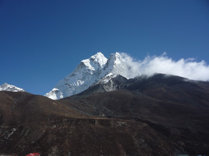
While trying to take this picture, Venkatesh dropped his sunglasses and inadvertently stepped on it. We had to get a new pair. The village of Pangboche had a store where a pair ("Made in USA") was available for Rs. 550. The valley below the trail had neatly laid out agricultural divisions. We were now much closer to Ama Dablam and it was making its presence felt befitting its stature as a sacred mountain to the Nepalis and Tibetans.
Animal traffic on the trail near Pangboche with Ama Dablam in the background
An establishment (Shree Dewa Lodge and Restaurant) advertised its offerings (Inside Toilet with Gas Giger (sic) Shower, Telephone Service) and prominently displayed the elevation (3985m). Behind the banner was the backdrop of Lhotse and Lhotse Shar (Everest could barely be seen). Down below, the Imja Khola river accompanied us.
 The trail proceeds
towards Pangboche (Imja Khola river below)
The trail proceeds
towards Pangboche (Imja Khola river below)
Pangboche had a few lodges and beyond that was a board that proudly welcomed visitors to Pangboche Primary School (built by Sir Ed in 1963). We passed the turnoff to the Pangboche Monastery (which is a nunnery) and kept going straight ahead. At 10:15 we reached the vertical village of Shomare. Our guide pulled another fast one by stopping at Junili Lodge and asking us to order lunch. This was way too early, but he said that it would be another 3 hours to Dingboche. Our calculations would have put it closer to 2 hours. We figured that he was probably hungry and gave in. It took a while for our Momos to arrive which we enjoyed quietly with Lemon tea, under the imposing figure of Ama Dablam which was very close to us now.
It was 11:15 before we started moving again and soon the narrow hillside trail gave way to a wide stretch of land with a lone resort type hotel in front of us. We could hear Imja Khola roaring below but we could not see it as we were well away from the edge. A snowy peak's tip appeared above the mountains that were closer to us. This was our first look at the beautiful Pumori which we will see in its full splendor a couple of days later. This view of Pumori came at the expense of Everest, which had vanished completely behind its cover. We were now over the 4000m. mark.
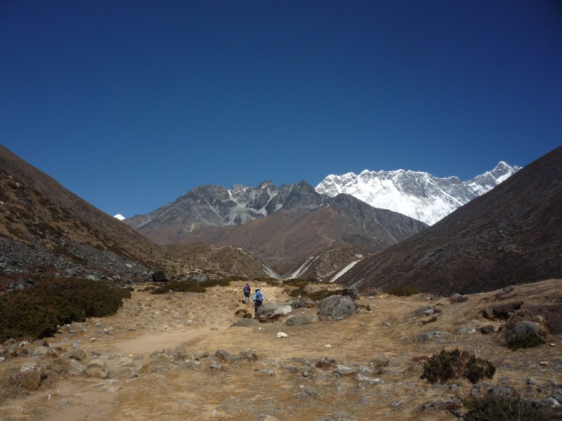 That tiny spot of white
center-left is Pumori. If you look carefully, you can see a trail climbing up
the brown mountain directly in front. That is the trail to Nangkartsang peak
which we climbed the next day.
That tiny spot of white
center-left is Pumori. If you look carefully, you can see a trail climbing up
the brown mountain directly in front. That is the trail to Nangkartsang peak
which we climbed the next day.
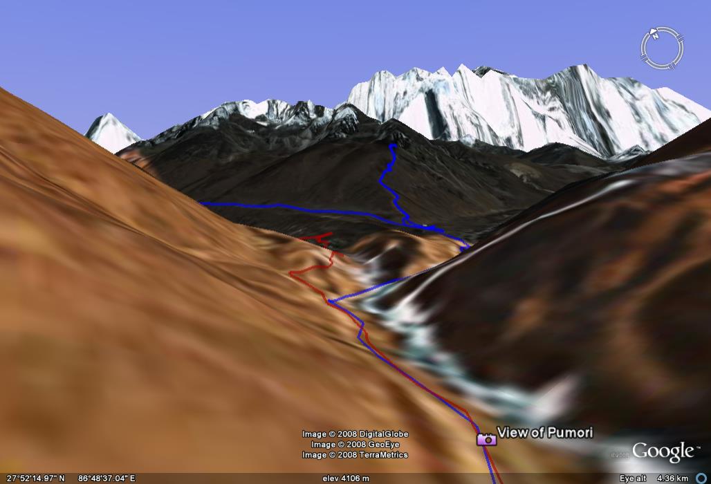
The same view of Pumori mimicked on Google Earth. Note the blue path that goes up the mountain (Nangkartsang) in front. That was our path for Day 6.
A short while later we descended a little to the cross the Khumbu Khola (tributary that was joining Imja Khola at that point) on a makeshift bridge. The combined river was now several streams running parallel over a wide expanse. The trail reverted back to its typical hillside contour and started climbing again.
Panorama near the Khumbu Khola-Imja Khola confluence s
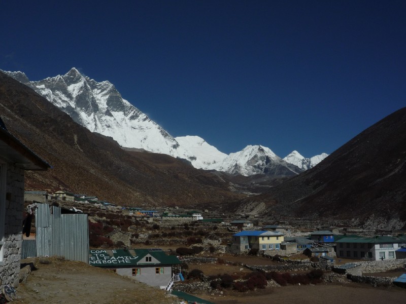
The town of Dingboche appeared behind a corner and in a few minutes we checked into Alpine Lodge for 2 nights. At this point we had a totally different view of all the familiar mountains we had been seeing the past 3 days. The route to Dingboche had actually skirted around Ama Dablam and we were now looking at its Northwest face.
 Ama Dablam presenting
its split profile, before the fog engulfed it
Ama Dablam presenting
its split profile, before the fog engulfed it
We were now at the same latitude as Tawoche and could only see its sideways profile.
 Tawoche
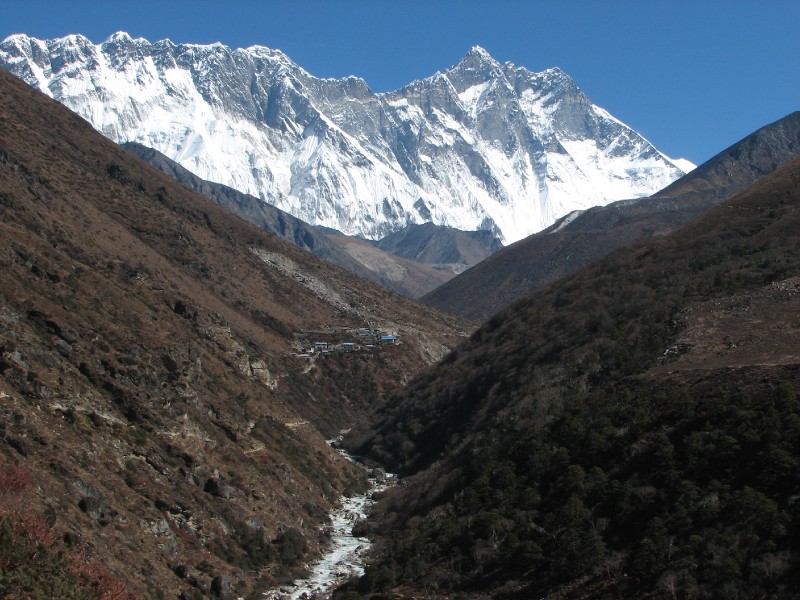
Lhotse and Lhotse Shar could still be seen (even the wall obscuring Everest was in turn obscured by Nangkartsang which loomed directly above Dingboche). There were new entrants to our list. Imjatse Himal (popularly known as Island peak - very popular as a climbing destination for trekkers who wish to extend themselves to do some ice climbing) seen center-right in the pic below and Peak 38 (which is the flat headed mountain between Lhotse and Island Peak). Not seen here is Makalu which is further to the right of Island Peak. (Speculation: The conical peak to the right of Island Peak is actually Makalu II . It is connected by the saddle to Makalu , which is not seen in the pic. Compare with photos taken the next day). We had just read that Makalu could be seen on the half-day trek to Nangkartsang peak (5000m). The alternative was the longer trek to the Chukkung Valley which would also have presented Makalu views. We decided on the shorter but more strenuous Nangkartsang Peak climb. It would be a workout as the peak is at 5000m and we would gain that elevation over a short distance (2.2 km/1.3 miles).
 Lhotse, Peak 38,
Imjatse Himal (Island Peak) and Makalu II
Lhotse, Peak 38,
Imjatse Himal (Island Peak) and Makalu II
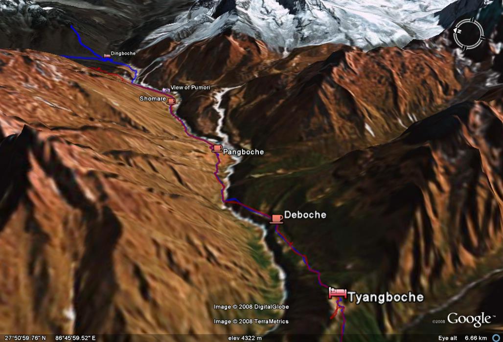
Day 4 path on Google Earth: The icy mass to the right of Dingboche is the base of Ama Dablam. The river featured is the Imja Khola.
When we arrived, it was warm enough for lodge guests to be sitting outside with a book. By the time we finished lunch, the weather turned chilly and soon everyone was rushing in and closing the door. The fog rolled in and obscured everything. The fire was started at 4 pm and not a moment too soon. The hall was filled with a large, single group who were served with diligence by a very attentive staff.
We discovered another favorite item that evening, Tomato Egg Drop Soup. We also tried the option of getting water boiled in the kitchen and filled in our metal bottles as an alternative to buying bottled water. It would cool off enough by morning to be drunk the next day. It could also serve as a hot water bottle for the sleeping bag, but that did not have the effect that we expected.
Fog rolls into Dingboche in the afternoon
| <--Prev |