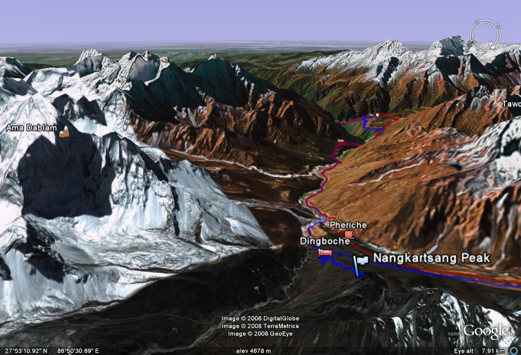
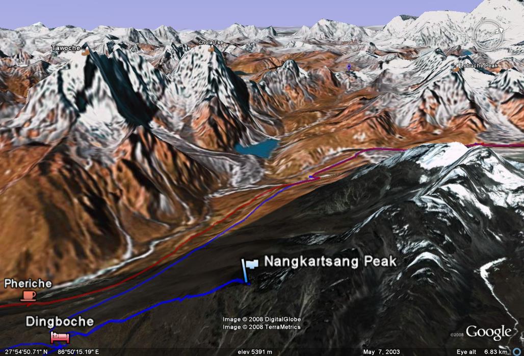
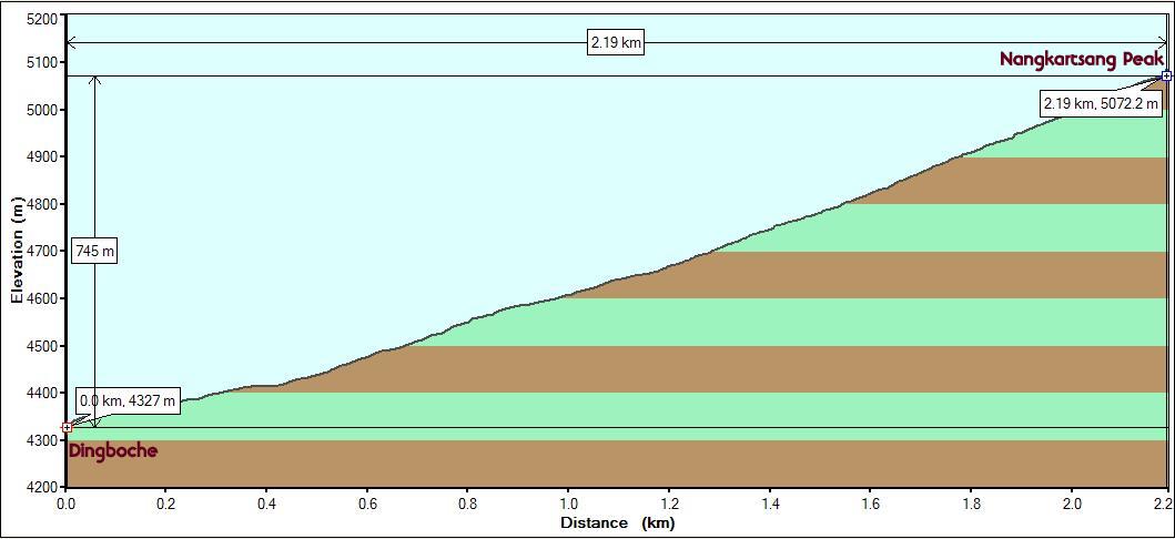
Starting
point : Dingboche (Altitude: 4327m/14175 ft. StartTime:
8:25 am) Interim point :
Nangkartsang Peak (Altitude: 5072m/16640 ft. Arrival Time: 10:45
asm) Endpoint : Returned to Dingboche (End Time:
12:15 pm) Distance : 2.19 km/1.36 miles (One
Way), 4.38 km/2.72 miles (Round Trip) Net Elevation Gain/Loss:
745m/2443 ft. (One Way, Steep, considering the short distance). Round Trip
(Zero, returned back to same point)
The trail started right behind our lodge without any
preamble. We could see the peak from where we started but were told that it
seemed deceptively close. It was a brilliant sunny day (like every other day so
far) but it was chilly due to the wind. We had many layers on but felt
uncomfortable. Just the typical starting problems that we had almost every day
since Day 2. But after the initial period of warming up passed, we were still
struggling. The altitude and the steepness of the terrain was having an effect
and we found the going very slow and tough. We were trying to pace ourselves to
avoid taking breaks and to avoid going out of breath. It takes some discipline
to match the rhythm of one's breathing and one's walking, particularly when it
was over a vertical slope.
The quick appearance of Makalu's peak was quite a boost and encouraged us
to push on despite our difficulties. The view to the west was an absolute
stunner. We could see Tawoche,
Cholatse (first time), the Chola pass and the Lobuche peaks. This was just a few minutes
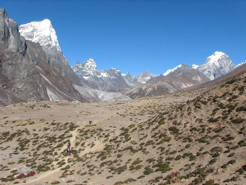
into the climb and it would only get better from now on. The trail from Dingboche to Lobuche passes left to right in the flat area in
the foreground of the picture. Between this flat area and the mountains behind
is the broad expanse of the Khumbu Khola
river valley. The town of Pheriche (not
seen in pic) also lies at the bottom. We would be able to view all these
when we get to the top.
So we dismissed all the negative thoughts about the
difficulty of the climb and kept pushing each other on. We put our cameras
away and concentrated on putting one foot in front (more like on top) of the
other. For a long time, we were the only people on the trail. We could see some
trekkers below, but they seemed to be staying put at a particular spot. A lone
Japanese trekker made steady progress and eventually caught up with us and
passed us. Our guide had taken the short path and was way ahead of us. As we
neared the top, the trail disappeared among large boulders which required the
use of hands to deal with. But we were quite close to the top
and negotiated the last stretch in anticipation of reaching the top soon.
It was a thrill to eventually get to the top at 10:45 am (2 hours and 20 mins).
It was time now to enjoy the views.
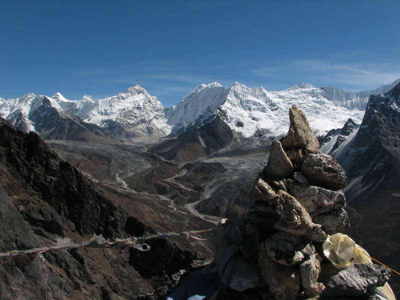
First, the mountain peak of the day, Makalu (5th highest on earth) with Makalu II and connecting saddle, Island Peak (in front of Makalu II), with the
Nangkartsang peak cairn in the foreground,
and Barun Tse (7,220m/23,688 ft) to the right of
Makalu. The path leading towards Makalu is the Chukkung valley which is part of the day trek that
was our other option.
Looking east from
Nangkartsang Peak at Chukkung Valley and Makalu
Makalu deserved a
close up shot...
Makalu (5th highest
mountain on earth)
The next one could easily be the most fabulous view of
the entire trip. Tawoche (only partially
seen at left edge), Cholatse (the mountain
tilting to the right), the Cholatse Pokhari
lake, the Khumbu Khola river
(white threads on the valley floor) and the mountains in the far distance. None
of these have star power, but this view was simply mesmerizing.
Khumbu Khola Valley from
Nangkartsang peak (looking west)
Not to forget our old friend Ama Dablam with its split profile and a couple of
blue blue lakes at its foot which could not be seen from lower elevations.
Ama Dablam and its
lakes
And our even older friends Kang Tega (with the full support of its
entire range with the nameless peaks) and Thamserku.
Looking south from
Nangkartsang Pk.: Kang Tega and Thamserku
Pictures of ourselves at the peak...
M and V on top of
Nangkartsang Peak (Makalu and Barun Tse behind)
We have clockwise and anticlockwise panoramic videos
from the peak. We couldn't leave either out. The views were that good. Go ahead,
you can start both of them simultaneously!
On the way down, we could see the village of Pheriche that was separated from Dingboche by just a ridge.
On our way down,Pheriche
in the right side valley and Dingboche at left
We made it back down
in an hour. Back at 12:15, we tried to use the laundry area outside to wash some
clothes and it turned out to be a bad idea as the cold water just stung our
hands. After lunch (Dal/Rice/Tarkari, Fried Momos and Tomato Egg Drop Soup and
Lemon Tea!), we did feel tired and cold in our rooms. We needed the rest
and got into our sleeping bags to stay warm. The room walls were of plywood and
were warped. But it had a window with a nice view of Ama Dablam.
Google Earth perspective of the view south of Nangkartsang peak:
Ama Dablam is at left, Kang Tega and Thamserku are in front. (Kusum Kanguru is hidden
by Thamserku in our photo, but is visible in this snapshot as the perspectives
are not exactly from the same point)
The fabulous western view from Nangkartsang peak mimicked
here in Google Earth. Tawoche, Cholatse and Lobuche peaks are seen along with
the Khumbu Khola river
 Looking east from
Nangkartsang Peak at Chukkung Valley and Makalu
Looking east from
Nangkartsang Peak at Chukkung Valley and Makalu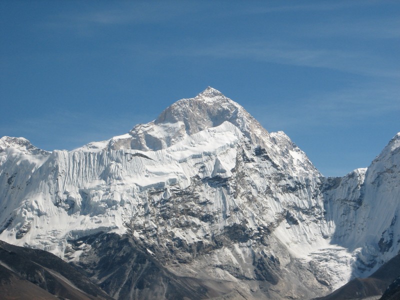 Makalu (5th highest
mountain on earth)
Makalu (5th highest
mountain on earth)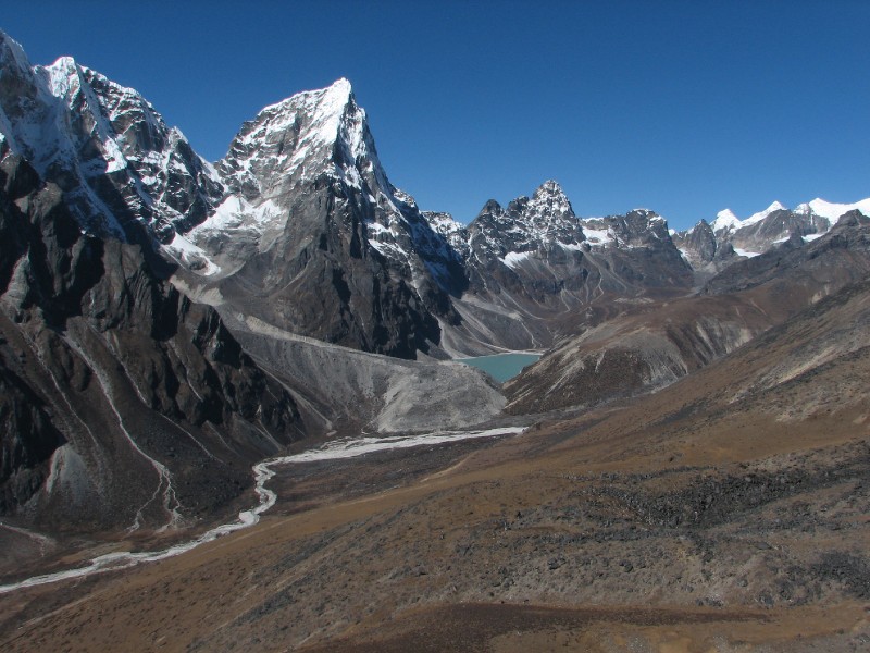 Khumbu Khola Valley from
Nangkartsang peak (looking west)
Khumbu Khola Valley from
Nangkartsang peak (looking west)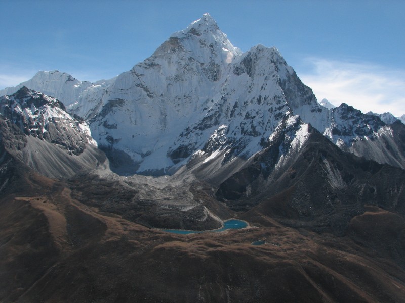 Ama Dablam and its
lakes
Ama Dablam and its
lakes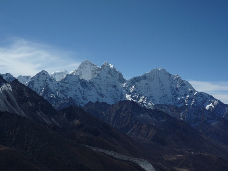 Looking south from
Nangkartsang Pk.: Kang Tega and Thamserku
Looking south from
Nangkartsang Pk.: Kang Tega and Thamserku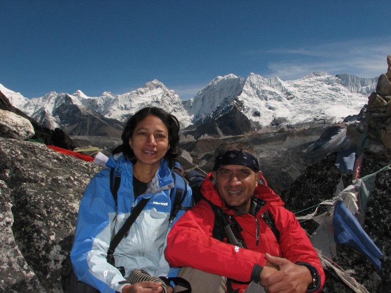 M and V on top of
Nangkartsang Peak (Makalu and Barun Tse behind)
M and V on top of
Nangkartsang Peak (Makalu and Barun Tse behind)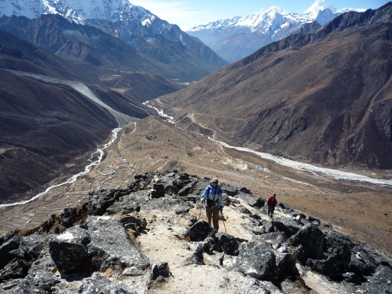 On our way down,Pheriche
in the right side valley and Dingboche at left
On our way down,Pheriche
in the right side valley and Dingboche at left